Quantcast
Channel: Scotland – Backpackingbongos
Viewing all 20 articles
Browse latest View live

A thousand shades of brown in the far north

$
0
0

There is a certain amount of relief in Reuben’s eyes as he lays in his bed this evening.  Finally a day when he is not dragged up a wind-swept mountain or up to his belly in bog.  The car is outside cooling down after a 1,193 mile round trip to Sutherland in the far north of Scotland.  I shudder to think what the final petrol bill is.

A total of eight days were spent backpacking among some really wild and empty landscapes, with an atmosphere totally unique to the far north.  The autumn colours are at their peak up there, I did not realise that it was possible to get so many different shades of brown.  The autumn light shining on all those yellows, reds and browns resulted in a real treat for the eyes.

Two backpacks were done in the company of Pete and our dogs Reuben and Dougal.  On our third backpack we were joined by his wife Fiona (aka TLF).  Three different backpacks enabled us to explore and experience three very different landscapes.  A photograph and a few words from each:

We started off by heading for three days into the vast Ben Armine Forest.  This is a huge sprawling area of high moorland that reminded me of the Monadhliath mountains.  We climbed to the summit of Ben Armine itself which is reputed to be the most remote Graham (for non hill baggers this is a hill between 2000ft and 2500ft).  The view from the top was breathtaking, with the Flow Country laid out at our feet.   The photo above is from the Bealach Easach looking towards Loch a Bhealaich.

Our second backpack saw us heading across the Flow Country itself.  This is a land of huge skies and it was slightly unnerving heading across what felt like an endless bog.  The reward was a lovely bothy at the end of the day.  The photo above is of Pete making use of the argocat track that thankfully went in our direction for a couple of miles.

Our final backpack was for three days amongst the rugged peaks of Assynt.  This is a real primeval landscape, the raw bones of the earth being thrust high into the sky.  The map is a chaos of contours, rocks and lochans begging to be explored.  Thankfully the weather was kind enough to let us climb high and enjoy the views.  The photo above was taken on the ascent of Beinn Leoid.  The Stack of Glencoul is in the middle distance with the mighty Quinag on the horizon.

As time allows I will put up three separate trip reports.  In the meantime I will leave you with my impression of a new bit of gear I took along.  I wore a brand new pair of ‘proper’ leather walking boots.  Eight days of wading through some of the sloppiest ground imaginable and my feet remained dry, comfortable and blister free.  I also did not fall over once.  Was that a deep intake of breath from the back?


Bothy vagabonds in the far north pt1 – Ben Armine

$
0
0

The word vagabond is derived from the Latin adjective vagabundus, “inclined to wander”, from the verb vagor, “wander”. It does not denote a member of a nomadic people, but rather an individual who follows a wandering lifestyle within a sedentary society.  It is also the title of one of my favourite New Model Army songs.

As a member of a sedentary society I crave getting into the hills for a wander, a strong desire to spend each night in a different place.  Tents are a marvelous modern invention which allow the backpacker to choose the perfect location to sleep every night.  However they are not always ideal at the end of October when exploring the far North of Scotland for a week, especially when you have a muddy dog in tow.  Noting a scattering of remote bothies on the map I decided that I would plan routes around them, they would be the basic framework for backpacking the wild places.  I debated whether to spend a week doing one long backpack or a series of shorter ones.  In the end shorter backpacks were the easiest option as you don’t have to carry as much stuff.  The car can be left to return to for supplies before moving on to somewhere totally different.  This gives the opportunity to cram a greater variety of landscapes into a short period of time.  Several backpacks also give the opportunity to seek the occasional real bed for the night and a beer!  To wander through remote hills and spend each night in a different bothy is my idea of heaven.

Unfortunately many miles lay between Nottingham and my slice of heaven, several hundred to be imprecise.  Thankfully my walking partner for the week Peter Edwards from Writes of Way lives in Glasgow, an opportunity to break up the journey.  I therefore had a billet for the night and was treated to some fine hospitality before continuing the drive the next morning.

Day 1 – 7.1 miles with 200 metres ascent

The Crask Inn sits in splendid isolation on the main A836, which runs between Lairg and Tongue.  A main road only in name as for much of its length it is single track.  We parked up opposite the Inn and popped in to let them know we would be leaving a vehicle there for three days.  Kai the landlady was exceptionally friendly and told me that the bothies we were heading to were well worth visiting, she even got out a photo album.  This put my mind at rest as previously I was not certain that they actually existed.  Dogs saddled up with their new rucksacks we set off eastwards across a large expanse of boggy moor.

The going could charitably be described as ‘damp’ as the track was effectively a series of ruts made by an argocat.  The going was slow, but spirits high as we let the wilds slowly envelope us.  Civilisation slowly drifting away.  Or was it?  After an hour of walking we turned around and noticed that the whitewashed building of the Crask was still firmly in view.

Up until this point the dogs had been on leads as the moor was dotted with some rather fine-looking Highland cattle, complete with pointed horns.  Cattle in open country make me nervous when there are no fences to jump over if the going gets hairy, thankfully they showed no interest in the dogs.

Finally the long boggy trudge across the moor ended as the path became more defined as it began to climb.  At the 350 metre high Bealach Easach the scenery suddenly changed.  The featureless moors were exchanged for a world of crags and lochs, the second most northerly Munro of Ben Klibreck to our left.  This is a landscape on a large scale and there was a feeling of entering a place not many people visit.

The path down from the Bealach was a joy to walk as it contoured high above the valley floor.  The dark crags and grey clouds gave a brooding atmosphere, enhanced by a series of bellows from red deer stags.  This appeared to spook Dougal and we told him that they eat chocolate labradors who give chase.  Good to teach him these stories whilst still young.

The footpath along the north side of Loch a Bhealaich appeared to be endless but thankfully the going was firm and dry and we made good progress.  The dogs had soon forgotten that they were wearing packs and were happily trotting in front of us.  I began to wonder about the water resistance of the packs as they had been dragged through several bogs, usually due to canine negligence when crossing the spagnum pools of doom.

As we crossed the isthmus between Loch a Bhealaich and Loch Choire our luck with the weather suddenly broke.  Curtains of rain drifted across the impressively large Loch Choire, blurring the horizon.  The early evening autumn light in the rain was magical and we both wished we had the means to capture it.  Reuben was the first onto the bridge across the river between the two lochs and I saw him temporarily freeze as it started swaying.  The rain started to intensify as we walked the sandy beach and we began trying to work out if anyone was in the loch side bothy.  Since leaving the Crask Inn there had been fresh footprints from a fell shoe, were they also headed for the bothy?  It was apparent that the place was tiny, would someone already there appreciate spending the night with two very wet dogs?  At moments like that your eyes can play tricks and I thought that I spotted smoke coming from the chimney.  As we finally approached, the door was locked from the outside, a clear indication that no one was home.

We entered a little gem of a bothy, our clothing and rucksacks soaking the wooden floor.  We were soon changed into dry clothing and had the stove lit.  Being a small one-roomed wooden building it quickly became toasty inside and the dogs claimed a prime spot to put their roll mats to have a doze.

Unfortunately it was not a restful night.  Firstly my bladder went into meltdown, I had to get up for a pee several times in the night.  The dogs were also rather excitable, any noise Reuben made woke Dougal and vice versa.  I remember at one point drifting off only to be bundled by 30kg of excited labrador.  The bubble wrap on the sleeping platforms made for a luxurious surface but any movement would result in several ‘pops’.  Peace finally came a couple of hours before dawn when the dogs decided that Pete’s thermarest was the place to be.

Day 2 – 10.2 miles with 825 metres ascent

Dawn comes late in the far north the week before the clocks change.  It was magical standing in the cold and still pre dawn light with a cup of coffee in my hands.  The rain had lasted most of the night but at some point the cloud disappeared and the temperature plummeted.  The only sound whilst I stood there was the occasional roar of a stag in a nearby glen.

Bothy mornings are easier than those in a tent.  We were in no great hurry and had time for a leisurely breakfast and numerous hot drinks.  The dogs were constantly on the prowl for a spot of food.

As the sun eventually appeared in our glen, the clouds melted from the summit of Ben Klibreck.  With the wooden hut and the surrounding hills the scenery had a definite Scandiwegian feel about it.

The plan for the day was to head deep into the hinterland of the Ben Armine Forest, a huge empty area on the map.  We had our fingers crossed that the weather would remain good, if so we would climb high to the summit of Ben Armine itself.

The track on the south side of Loch Choire was a delight to walk.  Trees (not counting those nasty christmas type ones) are a rarity in the hills this far north.  The track twisted and turned its way through a fine autumnal display.

Typically just as we approached the end of the loch near the lodge the sun disappeared and the sky once again began to look ominous.  The narrow path marked on the map heading south into the hills turned out to be a well maintain track and we were soon gaining height giving views back the way we had come.

Crossing the 420 metre contour we debated whether to continue along the track to the bothy or hit the hills.  As we had yet to have lunch we decided to climb higher, if the weather crapped out it should be easy enough to trudge down into the valley.  Initially the going was tough through the usual rough grass and heather.

Reuben however even though fully laden with his new pack was able to make climbing the hill look easy.

As is usual with the Scottish hills, the higher we climbed the easier the walking became.  I thought the hills had a resemblance to the Monadhliath mountains, although slightly lower.  As we reached the col between Meall Ard and Creag na h-lolaire that resemblance changed completely.  The view that greeted us is totally unique to this part of the world.  We were on the edge of a high plateau overlooking the magnificent Flow Country.  Low flat moorland stretched for miles towards the horizon, broken by the occasional hill rising sentinel like from the sea of brown.  The only man-made structures visible being coniferous forests, a single estate track and one solitary building many miles away.  I don’t think I have ever seen a view quite like it, a photo truly cannot do it justice.  We debated whether the land on the far far horizon was the Orkneys.  Just out of shot to the left was Ben Loyal, a magnificent looking peak.

Standing looking over such a huge expanse of land I felt a twinge of sadness.  There is the very real possibility / inevitability of the horizon being broken by up over 180 giant wind turbines.  Three wind farms are planned in the forests south of Strathy, right on the edge of the largest RSPB nature reserve in the UK at Forsinard.  My next post will describe a lovely backpack in that wild area.

On the hill there was a more immediate matter, lunch and shelter from the very cold wind.  A slab of rock provided a brief respite from the wind and we hunkered down to shovel food into our mouths whilst the dogs shivered.  We were quickly moving again as we could tell that the cold was getting to Reuben and Dougal.

From Meall nan Aighean to Ben Armine there was a fairly large descent and reascent.  Once out of the peat hag ridden col the ground was covered in a luxurious deep carpet of moss which was a joy to walk on.  We were truly in the middle of ‘big sky’ country with the moors seemingly rolling on forever.  The only thing detracting from the real sense of space and wildness was the distant Kilbraur power station and the Gordonbush one which is currently under construction.  Even from several miles away they dominate the softly rolling contours, breaking up the horizon.

We turned our backs and headed east into a vast high level bowl in the hills.

We took a gamble, we could either head for the path that runs directly to the bothy from the col at the south of Ben Armine and risk not getting across the river near the bothy.  Or, take a longer boggier route that would mean crossing the Allt na Seilich Bige earlier.  We took the easier option and were soon on a well graded path, the bothy suddenly coming into view.

Thankfully the river was low and we boulder hopped across dryshod.  Later whilst reading the bothy book we realised that this often is not the case.  We managed to time reaching the bothy to perfection as almost as soon as stepping inside the rain started and the wind picked up.  The bothy is located in pretty much as a remote a spot as it is possible to get in the UK.  It has been converted from the old estate stables and there are three sleeping platforms which are the old stalls as pictured below.

The evening was spent rather unsuccessfully trying to get a peat fire going.  A combination of heather for kindling, damp newspaper and not fully dried out peat made it a challenge.  The best we managed was a small amount of glowing when we blew furiously, zero heat was produced.  We retired to our sleeping bags early and thankfully the dogs were much more settled.

Day 3 – 11.1 miles with 360 metres ascent

The day dawned damp and misty with low cloud covering the hills.  An hour or so was spent soaking up the wild solitude around the bothy often with a cup of coffee in hand.  I had noticed the previous evening that Reuben’s pack had chaffed him under his front legs, which looked sore.  Dougal therefore volunteered to carry his food for him whilst his pack was strapped to the back of Pete’s rucksack.

The plan for the day was to head back to the first nights bothy and then retrace our steps back to the car.  The first kilometre or so was trackless and crossed some boggy terrain.  Dougal managed to fall into a deep and narrow drainage ditch, his panniers wedging him inside.  Thankfully I spotted it happen, otherwise we may have spent a long time looking for him!

We soon located the start of the hill path back to Loch Choire, thankfully this was often raised above the surrounding bogs making progress across the misty moors easy.

The climb to the top of the pass was just 80 metres and it was only when we reached the top that we got the sense that we were high up.  Our onward route descended for 300 metres through a lovely glen.

Movement on a hillside a kilometre or so away indicated that a stalking party was approaching a group of hinds.  Their clothing and movements clearly indicated that they were not hillwalkers.   Suddenly the hinds gave flight leaving the three figures far behind.

We were soon back at the bothy next to the loch for lunch, aware that we still had a few miles to walk before we reached the car.  It was when exiting the bothy that an argocat with three heavily tweeded figures approached.  We resigned ourselves to a good telling off.  It turned out that we had indeed spooked the deer, if we had have been two minutes later the stalking party would have been successful.  However they were very gracious and said that these things happen.  They were relieved that we would be heading off in an opposite direction to them.  We had the impression that the man and woman with the head stalker / ghillie were the owners of the estate.  When we departed I soon regretted asking for a photo as they all looked like they had stepped out of some period drama.

It was good to cross the sandy beach at the head of the loch, this time actually getting a view down its entire length.

The classic Highland bridge took us back onto the isthmus between the two lochs.

Pete, the class warrior then released his previously hidden feelings towards the landed classes……..

For the first time in three days the sun made an appearance as we made the climb towards the Bealach Easach.  It was good to do the climb unencumbered by waterproofs and wearing just a base layer.  The stags were once again bellowing from the same spot as a couple of days earlier.

We took a break at the summit of the bealach, the autumnal colours of the surrounding countryside lit up by the low sun.  The light was truly magical.

Unfortunately we both knew what awaited us on the other side of the pass.  The long boggy descent back to the car seemingly went on forever.  Even when the Crask Inn put in an appearance we knew that there was still an hour to go.  It was two tired, peat sodden dogs and their owners who finally stepped back onto tarmac as dusk approached.

Pete’s account of the trip can be found here.


Bothy vagabonds in the far north pt2 – Flow Country

$
0
0

As we reached the car after the Ben Armine backpack a lone figure approached us from the cottage close to the Crask Inn.  He introduced himself as John and told us that the woodburner was lit.  I had phoned the Crask the week before and inquired about accommodation.  The landlord and his wife were having their first evening out that year and the Inn would be shut.  Thankfully it transpired that they also own the cottage / bothy / bunkhouse just down the road.  A night would cost us £11 a night each, self catering.

With the car repositioned outside the cottage we went inside to say hello to John and have a nosy inside.  It turned out to be a very welcoming and homely place to stay, with the woodburner kicking out some heat.  It probably would not win any awards for decor or mod cons but for us it was perfect after a few days in the hills.  We even managed to bag a room each.  A convivial evening was spent in front or the fire with beer which the landlord had left for us to help ourselves.  Moffat John was great company and time passed quickly with his stories.

As I lay in bed that night I listened to the wind howl through the eaves, fingers crossed the weather would allow a safe passage across the flow country the next day.

The generator was off (mains electricity has yet to reach the Crask) when we got up at 8.00am, so packing and breakfast had to be done by torchlight.  It really surprised me how dark the mornings were up there.  With the car full of hounds we drove north through the village of Altnaharra, often mentioned as having the coldest recorded temperature in the UK.  The road twisting and turning alongside Loch Naver was delightful and we eventually parked up next to the bridge at Rhefail in Strath Naver.

Our destination for the day was to be the MBA bothy called the Croft House near Loch Strathy.  It is a place that I have wanted to visit for a long time now, although I would find it difficult to say exactly why.  Perhaps it is the fact that very little is written about it.  Or is it that not many people visit, seeing as there is a distinct lack of mountains nearby.  Maybe its the inaccessibility with either a 12 mile walk / cycle along forestry tracks or a boggy slog across the moors.

We opted for the boggy slog across the moors.

Day 1 – 5 miles with 270 metres ascent

The dogs were firmly leashed as we passed through the estate buildings at Rhifail, due to the presence of large amounts of sheep and pheasants.  We had set off from the car without a firm plan as to our exact route.  To be honest looking at the map it all looked a bit daunting with the numerous tiny lochans, streams and bogs.  It was going to have to be a case of make it up as we go along depending on the ground conditions.

Thankfully an argocat track led us onto and around the northern shoulder of Beinn Rifa-gil.  However as we crossed the shoulder passing Loch Warrender the full force of the weather hit us in the face.  It was a right old boggy stagger into the cold and damp wind.

Brief respite was obtained when we found a slab of rock to hunker down behind and eat our sandwiches.  My request at the Crask Inn earlier that day for a sandwich paid off nicely when I was presented with three cheese and tomato butties with homemade bread for the princely sum of  £2, bargain.  With the dogs suitably dribbling (after ensuring that no crumbs were left) we set off once more in an easterly direction, thankful for the argocat track leading the way.  A short descent and we found ourselves in a shallow basin, the flat moorland stretching away for miles.  Very atmospheric.

Unfortunately we had to part company with the argocat track and we continued across increasingly wet moorland, picking a course between two lochs.

We made it to a low but firm ridge without mishap and turned to look back the way we had walked.  There had been the potential for a spot of bother, the ground quaking as we made progress across it.  You need to keep your wits about you and be ready to retreat if the going gets too risky.

Route finding was now straightforward as we simply had to follow the deer fence that forms the boundary to the Strathy forest.  Initailly the going was not too tough and we let our guard down a bit whilst having a natter.  We suddenly found ourselves in the middle of a swamp and it was clear that to continue forward would be unwise.  A large detour eventually brought us back to the fence which we followed without further incident to where a new bridge crosses the River Strathy.  The dogs managed to spook a deer but only gave a half arsed attempt at a chase, they knew immediately that it really would be rather pointless.

The deer fence and a padlocked gate provided a bit of an obstacle to two men and their dogs.  Dougal and Reuben had to be manhandled over the very high ladder stile.  Reuben is a pretty calm 22kg, whilst Dougal is not so calm and weighs closer to 30kg.  Guess who was easier to get over?

The bothy was a substantial building and once again we wondered if anyone would be there, a very fresh set of prints from welly boots were on the ground.  It was empty and we set about exploring the building which has three rooms downstairs and a further two upstairs.  I bagged a cosy room downstairs complete with a wooden bed frame and portable tv.  The tv was a welcome bothy prank, similar to the telephone on the wall when I visited Keilderhead bothy.  Pete sensibly chose a room upstairs which would be heated by the fire in the room below.

The bothy shed was absolutely crammed full of wood, including old fence posts and pallets.  It was clear that you would have to be very poor fire lighters to not get a hot blaze going in this bothy.  Half an hour of sawing left us with a good pile of logs next to a very toasty fire.

You may have noticed a pair of boots drying to one side in the photo of the fire above.  This really is not a good idea folks and should not be done.  The end result for Pete was a dry pair of boots that had totally melted at the toes, rendering them a very painful fit.  The removal of Pete’s toes was not an option for the walk back, nor were the dog chewed pair of crocs he was wearing in the bothy.  It was going to be a long and painful walk back to the car for him.

With the exception of the boot disaster it was one of those classic bothy evenings in front of a roaring fire.  It’s just a shame that we were in bed by 10pm and totally missed the aurora borealis that was reported to have put on a show in the far north that night…………….

Day 2 – 5 miles with 140 metres ascent

We needed an early start as we were due to pick up Pete’s wife Fiona from Kinbrace station at lunch time.  At 7.00am it was still totally dark outside.  Dawn came slowly, soft light filtering through the low clouds and drizzle.  By 9.00am we were packed and ready for the walk back to the car.  A moment was taken to soak up the bothy environs before hoisting on our rucksacks and setting off the way we had come.

Now, I have managed to get through this entire post without mentioning windfarms.  Unfortunately it is not possible to write about the Croft House bothy without doing so.  Bear with me while I get this depressing bit over and done with.  The bothy lays slap bang in the middle of the proposed Strathy south windfarm, the planned number of turbines is 77.  Looking at the map of the wind farm posted in the bothy a turbine will literally be metres away from the building.  It gets worse, plans have also been submitted for the Strathy north windfarm with 33 turbines.  That’s not all folks as there is also scoping going on for Strathy wood with 28 turbines and Strathy forest with 21 turbines.  If my maths is correct that make a staggering 159 turbines in this area.

The proposed Strathy windfarms are bounded on three sides by the Caithness and Sutherland Peatlands Special Area of Conservation and Special Protection Area, accolades which recognise the European importance of the area’s habitats and birds.  The RSPB who own the neighbouring Forsinard reserve have been opposing the plans.  Being is such a sparsely populated area and miles from any sizeable habitation my gut instinct tells me that the Scottish Government will give the go ahead for Strathy north and south.  If this does become the case I urge you to visit before the turbines go up, it’s a magical spot.

Lets continue with the walk……………..

Actually there are not many words I can put to the return journey as it was identical to the walk in.  We knew what bogs to avoid and where to pick up the argocat track.  The light however was slightly better, so a few more photographs.

A tiny little green grassy mound in the middle of the moor was for some reason highly attractive for the dogs, maybe it is where the deer come for a rub?

Three hours later Strath Naver came into view, the descent filled with Pete’s curses as his toes were battered by his melted boots.

As we followed the track through the estate buildings at Rhifail I was stopped and asked, “Are you lost?” by a dapper looking chap, I replied that I was not and that we were heading back to the cars near the bridge.  I think that this was his polite way of telling me to get off his land.

Back at the car and out of our peat stained clothing we drove to the tiny village of Kinbrace with its railway halt.  The landscape that we drove through was outstanding, huge expanses of moor dotted with lochs and isolated mountains.  The sense of space and scale was impressive.  The single track roads were a joy to drive, at one point we drove for twenty miles and only passed two vehicles.

Fiona had fallen foul of the ‘modern’ British railway system and the dreaded, ‘bus replacement service’.  Who wants to pay good money for a train only to have to sit on a bus and miss your connection?  Apparently her journey was shared by panicked passengers who were unsure if they would meet their connections.  In the end they did not.  Thankfully a fleet of taxis ferried people to their onward destination and Fiona arrived only half an hour late.

The original plan for the afternoon was to head for a remote bothy on the north coast, however during the planning stage I had been overly optimistic.  We realised that it would not be possible to reach before darkness, crossing blanket bog above cliffs in the dark is not one of my favourite pastimes.  We elected to return to the Crask Inn, what a fine decision that was.

Moffat John was still firmly ensconced in the bothy / bunkhouse and the place was once again warm and welcoming.  We had dinner at the Crask itself this time and what a wonderful meal that was.  There was no menu and Mike the owner disappeared into the kitchen to rustle something up once he had finished tagging his sheep.  Lentil soup was followed by wild salmon and then apple and blackberry crumble.  Three courses for £12.95, that went down very well, especially with a couple of bottles of organic Black Isle ale.  After a convivial evening I slept very well, looking forward to our adventures on Assynt.

Pete’s version of events are on his blog here.  He was lucky enough to have a much more handsome chap to pose in his photographs.


Bothy vagabonds in the far north pt3 – Assynt

$
0
0

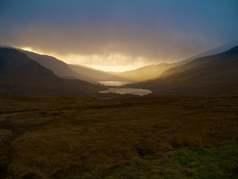
It was a beautiful morning when we left the Crask Inn, the low sun lighting up the soft contours of the surrounding hills.  We headed south to Lairg before heading north once more on the single track A838.  This road was busier than what we had been used to in Sutherland and I had to keep my wits about me, lots of sharp braking to pull into passing places.  You do have to realise that ‘busy’ is relative though!  It was a stunning drive, first along the length of Loch Shin before the mountains finally surrounded us.  The highlight was soon after passing the estate hamlet of Achfarry.  First of all Ben Stack rose ahead of us in a perfect pyramid like a classic childs drawing of a mountain.  Then across Loch Stack there was Arkle, its quartzite screes glistening in the sunlight, a really impressive sight.

We finally parked in a layby underneath the impressive ramparts of Quinag.  At an altitude of 220 metres the views north were impressive but tempered by the knowledge that at the end of the backpack there would be a five-mile slog along the road from sea level.

Day 1 – 6.7 miles with 480 metres ascent

As we got out of the car the towering slopes of Quinag slowly started to disappear under a veil of mist, it was clear that rain was heading our way.  Therefore we were fully encased in waterproofs as we headed along a boggy path to Loch na Gainmhich.  Shortly after exiting the loch the Allt Chranaidh turns into a fine waterfall.  There was a frantic moment as Dougal got within inches of the precipitous drop and became deaf to our calls to come back.  Thankfully it did not end in tears.

It took a while to locate the exact line of the footpath but once found it was mostly firm and covered in gravel, a bit of a treat after the previous couple of backpacks.  As we climbed higher the view of Quinag opened up, revealing that it is more of a mountain range than a solitary summit.  Curtains of rain drifting by added to the atmosphere.

We passed three very wet looking chaps coming the other way as we climbed.  The one at the rear totally ignoring our greetings with a very stoney looking face.  He only responded when Pete bellowed, “I said hello” a second time.  Rudeness in the hills will not be tolerated by Mr Edwards!

As we climbed, the Corbett Glas Bheinn started to reveal itself to our right.  It looks like it is a cracking hill, a complex mass of rock and lochans from the north.  I quite fancy returning one day to camp high up next to Loch a Choire Dheirg.

As we reached the summit of the path at the Bealach a Bhuirich a huge transporter plane flew below us and out along Loch Beag.  It was impressive seeing such a large plane fly below you through a narrow valley.

A friendly family was passed on our descent from the Bealach, I think that it is great seeing kids out in the hills enjoying themselves.  An easy crossing was made of the stream that feeds the waterfall Eas a’ Chual Aluinn.  This I believe is the highest waterfall in the UK and a boggy path descends alongside the stream to the top of the falls.  However lunch was calling and we would get to see the falls from the bottom later on in the day,  hopefully a much better viewing point.

A rocky perch was found on which to eat our lunch and soak up the rough and rugged surroundings.  We spotted a couple descending from the Bealach towards us, Dougal unfortunately could hear but not see them.  This set off a series of deep barks which after a minute or so Pete tried to stem with a hug / restraint.  This set off a couple of unfortunate events for Pete.  Firstly sliding over rough rock to Dougal left a hole in his brand new waterproof trousers.  Secondly the sandwich that he was eating was left literally inches from Reubens nose.  Reuben could not resist the smell of salami and cheese, the first time since I have had him that he has stolen food.  Pete remained chipper though and helped Fiona with her sandwiches.

Setting off once more I regretted taking a 1:25,000 scale map rather than a 1:50,000 which is much more useful in the Scottish mountains.  The map I was carrying simply had too much information due to the complex terrain.  Therefore it was hard to read the contours and see where the path went.

The scenery throughout however was breathtaking, a real contrast to the previous couple of backpacks in the far north.

It was during one of our frequent map checking stops that Dougal managed to get hold of one of Fiona’s gloves.  An entertaining chase began! I had to put the camera down in the end when Reuben’s terrier nature suddenly shone through………..

With the glove back on Fiona’s hand we managed to locate the path that took us safely through the crags to the bottom of the valley.  Although clearly rarely used the path was a delight with grassy switchbacks down the rough hillside.  In time I would image this old stalkers path will be reclaimed by nature.

When planning the route I was worried that crossing the Abhainn an Loch Bhig would involve a lengthy detour upstream.  Thankfully water levels were low and we all got across dry-shod, some needing more persuasion than others.

Seeing as the Eas a’ Chual Aluinn is reputedly the highest waterfall in the UK, it was a slight disappointment to be honest.  In spate I would image it would be an impressive sight but it has competition from the awe-inspiring scenery that surrounds it.

After the pleasure of following well constructed stalkers paths, the terrain through the valley towards Loch Beag meant tough going.  A mixture of heather, tussocks and the odd patch of tricky bog.

Reuben is usually a nimble-footed creature in this sort of terrain and I often found myself wishing that I could move through rough ground with the same ease.  However even those with four-legged drive can get things wrong.  Just as he was about to leap over a particularly peaty bog the ground under his front paws gave way and he entered the black stuff nose first.  He looked a bit sorry for himself afterwards.

As we finally got our first sight of Loch Beag the afternoon light was slowly fading, providing a beautiful scene.

There was not a breath of wind and the loch was almost ripple free like a mirror.

With the shore reached there was still a way to go across rough and boulder strewn ground.  For me the highlight of the afternoon was the spotting of a trio of Common seals causing ripples on the loch.

Finally the bothy came into view and our thoughts once again turned to whether or not anyone was in residence.  Initially we thought our luck was in, until right at the last moment when we caught a whiff of wood smoke.  I was the first one to enter and my impressions of the inhabitant were not too favourable.  I had the feeling that he was a little underwhelmed to suddenly have our company.  After a quick nosey around I left to get my pack whilst Pete popped in to say hello, he soon exited with the same opinion as me.  The bothy was a tiny two-roomed affair and the occupant had his gear spread around both, three more people and two wet dogs would have been a crowd.  We made our excuses saying we would pitch our tents and join him later that evening.

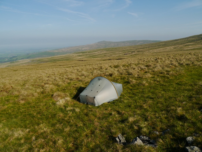
I managed a lovely pitch metres from the shore, the rocky ground causing a bit of a challenge for my tent pegs.  Whilst erecting the Scarp1 I noticed Reuben enjoying something by the waters edge.  It turned out to be a seal skeleton with a few white fatty bits and what looked like a hand remaining.  Although Reuben looked like he was tucking into the best meal of the trip he was firmly pegged down by my tent to stop his disgusting eating habits.

Pete and Fiona elected to pitch as far as possible from me, perhaps my deodorant was finally wearing off?  As we all settled in our respective tents the rain started, first softly and then in earnest.  Once I was changed out of my muddy gear I decided that I was not leaving my tent for the night.  I snuggled down for the evening, cosy in my nylon cocoon for the first time that week, enjoying plenty of hot drinks and a homemade chilli fandango.

My initial plan for the tent arrangements with Reuben was for him to sleep in one of the porches on a foam mat.  However after watching him shiver and look at me rather forlornly he was allowed in the tent where he did his best to curl up as close as possible to me.  I was thankful that ticks had been almost non-existent that week.

Day 2 – 9.4 miles with 1,080 metres ascent

The wind picked up in the night and the rain continued to hammer on the thin nylon.  However I had what was probably the best nights sleep of the whole week, comfortable and secure in my own little world.  The wind and rain stopped at dawn leaving low clouds over Quinag.

After breakfast we went into the bothy and realised that we had totally misjudged the occupant Alan.  He had been out in the hills since April on his annual pilgrimage to the Highlands.  Seven months is a long time to spend alone wild camping and in bothies and he said that he had not really talked to anyone for a few weeks.  We had confused standoffishness with being quiet and reserved.  Alan even had a bag full of dog treats just in case he came across hounds on his travels, a huge thumbs up in my book.  After chatting with Alan for a while we left with regret for not spending time in front of the fire with him the night before.  There is probably a lesson there somewhere.

It was difficult to judge what the weather was going to do, as sunshine would quickly alternate with a threat of rain as we headed along the stoney beach to the Glencoul river.

The path marked on the map turned out to be a rough landrover track, thankfully the passing of time meaning that its edges had been softened by nature.  Easy conditions underfoot meant that quick progress was made up the glen.

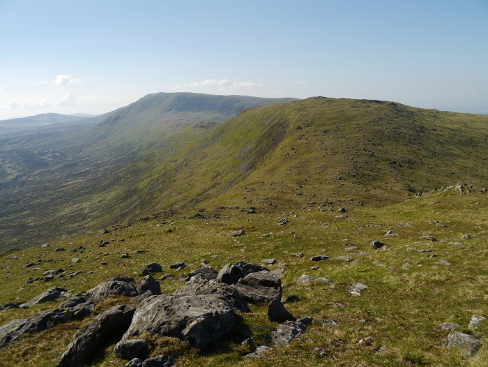
For a hill of less than 500 metres in height, the Stac of Glencoul is a dominating presence, appearing as an unattainable dome of rock when looking at it front on.

However as height was gained and we journeyed further up the glen it became more apparent that it was in fact part of a moorland ridge.

At the outflow of Loch an Eircill we headed directly north, climbing steep heather slopes above a deeply incised stream.  The ground soon levelled out and we started picking our way upwards through bogs and rough grass towards a band of crags.  The plan was to contour round them and climb to a small lochan for lunch.

As expected, as we climbed the views opened up around us showing off the roughness of the surrounding terrain.  The Munro of Ben More Assynt still firmly with its head in the clouds.

To the west the tops were slowly shaking off the cloud, a brilliantly chaotic view of bog, rock, lochans and dramatic peaks.

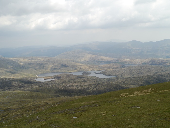
Lunch passed without incidence and we were soon climbing the south-west ridge of Beinn Leoid, the bogs giving way to firm grass.  A glimpse of the view directly to the south was of gentler moorland terrain with a complicated network of lochs.

The view back towards the rugged west and Quinag got more superb with every step.

Contouring the south-west top of Beinn Leoid my eyes were drawn to the extensive vista to the south-east, the sort of view that makes my heart leap with joy.  We could almost see across the whole width of Scotland, the massive Loch Shin taking a sinuous course through a land of gentle contours.  It was simply lovely, something a photo really cannot do justice.

Reuben was sitting patiently next to me whilst I stood admiring the view with a slack jaw.  It then suddenly occurred to me just how much he blends in with the autumn grasses.  Maybe the true home of the Staffy is the mountains and moors rather than the urban environment.  He is still the only one of his breed that I have seen enjoying the freedom of the hills.

It was then a gentle walk to the summit across cropped grass and boulders.

The summit views were breathtaking, taking in a wide variety of scenery.  From the rugged seascapes of the west, to the lonely mountains of the north and the rolling moors of the east.

It would have been easy to hang around on the summit for hours but it was evident that the dogs were getting cold.  Even Dougal in his thick brown coat was curled up behind the wind shelter.  A ridge leads from the summit in roughly a northerly direction, the upper slopes made up of awkward boulders.

Lower down, easy grass once again dominated and we were able to appreciate for the first time what a fine hill Beinn Leoid is when viewed from below.

Mountain hares have a habit of waiting until you almost tread on them before making their presence known.  The pure excitement of this happening in front of two hounds was too much for them and they were off on the hunt.  They stood no chance really as the hare disappeared over a rise, but they followed in hot pursuit until they were out of sight.  Dogs running off at speed in the mountains is not a good thing, their brains not processing danger like ours, it would only take a cliff for things to end in tragedy.  Thankfully a minute later Rueben and Dougal reappeared, minus the hare.

Luckily they were both looking in the opposite direction when the second hare broke cover and it slipped away unnoticed.

The grassy slopes of the hill soon gave way to flat boggy moorland and we headed to where we hoped the path marked on the map started.  Our navigation was spot on and we were once again descending grassy switchbacks until the path became a landrover track.

We were soon back at sea level and approaching the fjord like Loch Glendhu, the bothy and nearby lodge coming into view.

For the second time in a row smoke was spotted coming from the bothy chimney.  After our misjudgment the night before we decided to make more of an effort with regards to the occupant.  Unfortunately it was clear that he was not a big fan of dogs after informing us that he does not like them jumping up, going near his food or sleeping on his bed (Reuben was making a beeline for his thermarest at that very point!).  The bothy is a big four roomed affair so we left him to it and did our own thing in the room next door.  It was evident that Reuben had overdone things that evening as he was very keen to lay down on his mat and not move.  When he did, it was done very stiffly and it looked like his back legs were aching.  He had been very active during the day, probably covering at least four times the distance as the humans, the race after the hare probably doing him no favours.  It is hard to get a dog to understand that it needs to pace itself!  A role reversal as Dougal carrying both his and Reuben’s dinner was the dog closely at heel all day.

Day 3 – 4.5 miles with 290 metres ascent

An unusually mild morning meant that breakfast was eaten outside the bothy, a great place to soak up the surroundings.

Fiona is obviously made of hard stuff or morphs into a mermaid as she disappeared for a while to go for a swim in the loch.  For me just looking at the clear water made me shiver and collecting water from the stream made my hand numb.  Packed up we set off back towards civilisation.

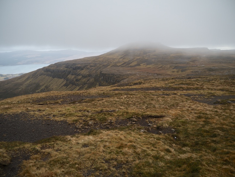
The map gives the impression of a nice level walk along the shores of the loch.  The reality was a rollercoaster of a track, climbing up and around walls of rock, brilliantly engineered in places.  The view back into the jaws of Glendhu was mightily impressive.  On the other side of the loch from the bothy we noticed a massive rock fall, clearly shown on the right hand side of the photo below.  I bet that made a huge roar as it happened and I hope no one was in its path.

Once again Quinag hogged the limelight, dominating the view.  One day I am keen to return to climb its peaks.

As we reached the public road the heavens opened, reminding us how lucky we had generally been with the weather.  There was now the slight issue of getting back to the car, as it was a 5 mile uphill slog away.  The walk with a backpacking sack really did not appeal.  In the end it was decided that Pete and Fiona would hide with the dogs whilst I would try my luck hitching.  I had checked out the bus timetables prior to the trip and there would not be one for several months!  I stood on the main road and waited and waited in the rain, vehicles are not frequent in these parts.  It took nearly 20 minutes for the first and second vehicles to pass without stopping.  Thankfully my charm was spotted by a young woman who had parked for a brief walk at the car park next to me.  After initially looking uncertain she offered me a lift and went out of her way to deliver me at the top of the pass.  A fine end to a memorable week in the far north.

You can read Pete’s version of events here.


Dessicated

$
0
0

Five days in the sun has left my face as dry as the West Highlands.  After a long period without rain the ground that is not frozen solid has a crispy texture to it.  The rivers have slowed to a trickle and the side streams are dry.  By day the sun beat down under the bluest of skies, feeling warm when sheltered from the biting easterly.  Nights however were brutal, ice silencing the rivers and sending me shivering into my sleeping bag  Whilst the rest of Scotland has been groaning under the weight of snow, this remote land on the other side of the Corran ferry is largely snow free.  My plans to do a long glen backpack quickly changed as I decided it was essential to get high.  I am glad that I did.

P1040684

Looking towards Ben Nevis from the summit of Sgorr Craobh a Chaorainn.

P1040694

The splendidly long, remote and beautiful Cona Glen.

P1040751

Looking north from the summit of Bealach an Sgriodain at dusk.

It was the Easter weekend and I passed one other hiker in five days.  Just how I like it.


Backpacking Ardgour – the Cona Glen Corbetts pt1

$
0
0

I sneaked out of Nottingham before dawn on the Good Friday, heading north fuelled on pain au chocolat and strong coffee.  Surprisingly traffic was light and seven hours later the Real food Cafe in Tyndrum made me part with my cash for their fantastic fish and chips.  With a happy stomach I did the best I could to keep my eyes on the road whilst passing Rannoch Moor and Glencoe.  The Peaks were absolutely plastered in white, dazzling in the sun under a blue sky.

I timed the Corran ferry to perfection.  I approached the slipway just as the last of the vehicles was loaded, getting on in the nick of time.  Five minutes later I was the only vehicle that turned right on the single tracked road, the rest heading towards the fleshpots of Strontian.  Although only on the other side of Loch Linnhie it felt a million miles from the bustling A82.

There is space for several vehicles to park at the entrance of the Cona Glen, although I was the only one.  As I got out of the car the sun was beating down and with no breeze it could almost have been mistaken for summer.  On this side of the Loch the hills around me appeared to be almost free of snow, although I could not see further up the glen.  This gave me a bit of a dilemma.  Would I need the ice axe and crampons that were in the boot or should I just take some microspikes instead?

In retrospect a bit of a daft debate to be having in a warm sheltered valley.  In the end I just took my crampons.  Now was that a wise decision?

Day 1 – 16 kilometres with 440 metres ascent

Ardgour day 1b

Once past a couple of buildings I had that wonderful feeling that you get when entering wild country.  I knew that each step would take me further and further away from the hum drum of daily life.  I passed and was re-passed a few times by an estate worker on a tractor feeding deer.  Finally he rumbled off down the glen leaving me with the sound of silence.  For the next four nights I would be alone, the only contact with the outside being if I could get reception on the summits to call my wife.

The lower part of the glen has some beautiful woodland around Doire Driseach, an area I had initially planned to camp.  Even after driving for nine hours and it being past 4.00pm I decided to push on and see how far I could get before dark.  It has to be said that there were many tempting places to pitch a tent within that first hour.

P1040639

P1040640

The track gave rapid progress and I was soon passing the Corrlarach bothy.  Unfortunately it was locked and after pressing my nose against the windows I walked on.  I was rather jealous of its location with some grand looking Scotts Pine nearby.

P1040644

P1040645

The air was absolutely still and I soon worked up a sweat, stripping down to just a base-layer.  I was getting tired but decided I would camp right at the head of the glen no matter whether darkness overtook me.

Further up a strange conical mound rises above the river, from that point onwards the scenery would take on a wilder feel as the last of the trees were left behind.

The sun dipped below the mountains in front of me and immediately I had to pull my jacket back on.  Looking east I noticed that Ben Nevis had taken on a pink glow, everything lower plunged into shadow.  I retrieved my torch from my pack, ready for when my eyes finally needed battery operated assistance.

P1040648

The solid landrover track was replaced by a much older and rougher version, ruts through the bog and heather.  The illusion of being in the middle of nowhere was soon shattered when I came across several diggers, mounds of earth and a mashed up looking landscape.  This part of the track was being upgraded, starting higher up and working its way down.  I hope that nature takes its course and heals the wounds.

As darkness started to approach I noticed an unusual smell in the air.  A sharpness that burnt my nostrils.  With the air perfectly still and dry and with stars starting to appear overhead, I realised what it was.  It was the smell of cold descending on the glen.

The final few minutes were undertaken by headtorch, I finally arrived at a large loop on the river where cropped grass provided a perfect spot to camp.  As I was pitching frost bagan to form on the tent in front of my eyes.  I measured -4C and it had only just got dark, it was going to be a cold night.

Day 2 – 10 kilometres with 850 metres ascent

Day 2

It was a night of extraordinary coldness but also dryness.  As one point I blew my nose to find within minutes the tissue had frozen solid.  The river that I was pitched next to became silenced in the night as ice imprisoned its surface.

I woke to find the sun warming the tent and the sound of the river cracking and groaning as the ice started to recede.  I was quickly up, a coffee in hand to take in the spot that I had arrived at in the dark.  And what a spot it was!

P1040649

P1040650

The night before I had decided that I would not do the planned long glen route, but instead take it easy and try to summit a few hills.  After breakfast I packed a few things in my sack and left the tent to relax in the sun.

The terrain was immediately steep and rough but I was quickly getting a measure of the scale of my surroundings, the river cutting a large loop across the head of the glen.

P1040653

The main track to Callop was reached and I enjoyed a short distance without being pestered by contours.  The track soon continued downwards and I started up the steep trackless slopes of the Corbett Sgorr Craobh a Chaorainn.  With a lack of general fitness it was tough going, but I reminded myself that at least all my heavy gear was in the tent and not on my back.  I was soon resting and enjoying the view down the Callop Glen and towards Streap.

P1040658

Whilst at the same time eyeing up the steep and rough slopes that I still had to climb.

P1040665

I always find that once a good amount of height has been climbed something switches in my mind and the going becomes easier.  For some reason that usually comes at about the 600 metres contour.  Maybe my legs and lungs sense that the ordeal will soon be over.

P1040667

Arriving at a col below the main summit I got a good view of Sgurr Ghiubhsachain which I had planned to be my second Corbett of the day.  The steepness of its slopes and the snow made me feel just a little bit nervous.

P1040668

The actual summit of Sgorr Craobh a Chaorainn is guarded by a line of cliffs on the south western side, these looking rather formidable when I saw them for the first time.  However I spotted a line through easier ground towards the south.  The going was rather steep and loose but I soon found myself approaching the summit cairn.

For such a low summit (or because of it) the panorama was simply breathtaking with the crystal clear air.  Ben Nevis took centre stage but also on offer was the length of Glen Spean, the Glencoe hills and an array of peaks spreading towards Knoydart.  However more than a match for any of the famous showstoppers was the rugged land closer to hand.  I could not understand why the place was not crawling this bank holiday weekend with such good weather.  They say that a picture is worth a thousand words, so I will let a few do the talking.

P1040674

P1040677

P1040679

P1040681

P1040684

P1040690

The descent was tricky whilst I searched for the line I had used on the ascent.  It’s amazing how things appear so much steeper when going downhill.  Once back below the cliffs it was an easy yomp downhill to the col followed by an ascent up grassy slopes.  The rocky summit of Sgurr Ghiubhsachain began to look intimidating, the route mentioned in guidebooks appearing as a solid wall of snow-covered rock.

P1040692

The map suggested that it could be possible to bypass the steep rocky section and sneak up to the summit through a breach in its southern defenses.  A grassy contouring line below the crags gave a view down the entire length of Cona Glen.

P1040694

The final half hour to the summit is one that I will file away in the memory bank with the label ‘Experiences learned’.  The plan to sneak around the crags was going well until I came across a large wide gully filled with snow.  This was south-facing so had turned into slippery mush.  My crampons were rendered useless and instead an ice axe would have been the tool to use just in case I slipped whilst trying to get across.  There was no way I was going to attempt a crossing without, as any slip would have meant a fast exit into the glen below.

I spotted a series of snow free grassy ledges above so started the process of linking them together.  This turned out much harder than anticipated and there were a few worrying moments of climbing up ribs of rock that were steeper than I would have liked.  My knees were knocking a bit by the time I reached the trig point.  I should have simply stuck to the established route.

The view was good though!

P1040707

P1040709

P1040710

I knew that fellow blogger Andy Jones from Surfnslide was in the adjacent glen doing a spot of Corbett bagging with a mate.  There was talk of trying to meet up.  Therefore I fired a text to see where they were camping, letting him know that I may turn up the following evening.

Thankfully the south-west ridge provided a much gentler descent, the view towards the Glenfinnan viaduct being one of mountain perfection.  My original plan had been to continue over the subsidiary summit of Meall nan Creag Leac but I could not summon the energy.  Instead I took a knee jarring descent straight down into the glen, which now looks seemingly impossible on the map.  The Corbett Druim Tarsuinn which would hopefully be my objective the following day looked to be even more plastered in snow and down to a lower level.

P1040715

Once again it was pretty much dark by the time I got inside my tent, the temperature already having plummeted to the wrong side of freezing.

Lesson learned so far on this trip:  Never judge mountain conditions by peering up from a warm sunny valley!


Backpacking Ardgour – the Cona Glen Corbetts pt2

$
0
0

Day 3 – 9 kilometres with 800 metres ascent

Day three

After another very cold night I enjoyed festering in my sleeping bag for a couple of hours whilst the morning sun warmed the tent.  There is something deeply satisfying about not having a schedule when in the hills, you can make things up as you go along.  One of the benefits of backpacking solo.  Especially when you prefer the slackpacking approach like I do.

I thought that I did pretty well, eventually getting up at 9.30am.  However there was some initial confusion when the time on my mobile disagreed with my watch.  I then remembered that the clocks had gone forward and it was in fact 10.30am.  Now that’s not so good.

I just about managed to pack up and set off on the morning side of noon, heading back towards the diggers.  Despite the dry and crunchy ground I still managed to find one well camouflaged booby-trapped bog.  I left a trail of black goo in my wake as I crossed the Cona River and made my way up towards an un-named bealach.

P1040718

P1040723

I passed the only person that I would see all weekend as he descended towards the Cona Glen.  A brief chat and we went our separate ways.  With no pack on I wondered if he was wild camping nearby as the nearest road was a few hours away.

Upon reaching the rugged bealach my intention to meet up with Andy in Glen Scaddle fell by the wayside.  I heard a trickle of water and found a patch of flat ground that had been exposed to the sun.  I made a spur of the moment decision to pitch and then climb Druim Tarsuinn without a full pack.  With tent up and water collected I cooked a hot lunch and lazed around for half an hour.  I then packed a few essentials before heading up grassy slopes, careful to look back and pinpoint where the tent was pitched.

P1040725

Route finding was easy up the broad grassy ridge, two sets of old fence posts leading the way.  Behind me Stob a Chuir looked much bigger than the 717 metres on the map indicates.

P1040727

To get to Druim Tarsuinn I had to cross the subsidiary summit of Meall Mhor, a few metres lower.  The snow on the summit was extensive, good firm stuff which allowed my boots a solid bite.  Crampons were not really necessary as the Meindl’s sole provided an astonishingly good grip.  I was careful to avoid slopes where a slip could be dangerous.  Once on the snow I yomped along, enjoying the satisfying crunch underfoot.  Even the subsidiary summit of Meall Mhor had a subsidiary summit.

P1040734

P1040741

It was a steep clamber down the west ridge before the final climb of a hundred or so metres to Druim Tarssuinn.  The sun was getting low in the sky, painting my surroundings with a soft glow.  I sheltered behind the summit rocks and gazed out towards the west.  I could clearly see Ben More on Mull amongst an array of peaks that I could not identify.  If it had not been so cold I could have sat there for hours taking it all in.

P1040743

P1040746

P1040749

P1040750

P1040751

P1040753

P1040760

Much more pressing than the cold was the fact that the sun was about to set.  It had taken me longer to get to the summit than originally anticipated.  I did not want to be wandering these craggy snow-clad hills in the dark.  I started descending, coming face to face with Meall Mor which I would have to climb once more.  It looked huge, capped by the setting sun.

P1040762

Steep slopes mean that height is gained quickly and I was once again close to the summit.  Looking west I caught the sun just before it disappeared behind a bank of cloud, its rays doing little to penetrate the sub-zero temperatures.

P1040763

P1040764

Crossing a large patch of snow I started to hear a strange noise and had the feeling of being followed.  I nervously continued and then stopped, looking over my shoulder.  There was nothing there and the noise stopped when I stopped.  I repeated this several times, each time I stopped the noise stopped.  I then realised that my right boot had developed a bit of a squeak.

After the sun had gone down the sky took on a strange pink and purple hue.  Once again I was transfixed but aware that time really was not on my side.

P1040770

I made it back to the tent literally moments before I could no longer see without a torch.  Although another cold night, camping above the glen stopped the temperature plummeting so low.  After eating I settled down with my kindle to be sucked into a strange world conjured up by Haruki Murakami, where two moons hang from the sky.

Day 4 – 12 kilometres with 165 metres ascent

Day four

The previous evening I had decided that mountains would be off the menu today.  Instead I would have a nice leisurely stroll down the glen to find a pitch not too far from the car.  Because of this it was on the afternoon side of noon when I finally packed up.  However before doing so I took the opportunity to photograph the Scarp1 in a wonderful location.

P1040771

P1040773

P1040774

Prior to pitching the day before I had a quick glance at my route down into Gleann an Lochain Duibh.  I have to admit that it had made me feel a little nervous as the slopes appeared to be almost vertical grass.  It was therefore with a little trepidation that I set off on a course following the stream.  It was indeed steep but I managed with unhappy knees to get to the glen floor in one piece.  Not a descent to do in the wet.  The scenery was as usual spectacular, first with views along upper Glen Hurich.

P1040779

And down to the frozen Lochan Dubh.

P1040785

There was a curious optical illusion when I thought that I was almost level with the loch.  It turned out that I was still over a hundred metres above.  The leveling out of the ground after such steep slopes led my brain to believe I was walking on level ground.

The shore of the loch was a fine place to sit, sheltered from the breeze it was only the ice that gave the game away that summer had not yet arrived.

P1040786

P1040788

P1040792

The path that is marked through Gleann an lochain Duibh failed to materialise on the ground until I was half way along it.  I can’t imagine that it gets much foot traffic, therefore the surrounding bogs must have swallowed it up.

P1040793

Close to where the Gleann an lochain Duibh meets Gleann na Cloiche Sgoilte I spotted a lush patch of vegetation that was sheltered on two sides by a rocky outcrop.  It looked a perfect spot to sit and cook some lunch.  Sitting there in my base layer I felt very pleased with myself.  However that feeling did not last very long.  You may have noticed that I have not used the word ‘tick’ once yet in this write-up.  Due to the cold weather and frozen ground they had been completely absent.  However sitting there in that very warm microclimate I picked up my food bag and noticed that its surface was crawling with the little critters.  In fact everything that I had dumped out of my pack was.  What was meant to be a leisurely break was spent moving elsewhere and then flicking each and every one off.  They were at the nymph stage so absolutely tiny.  Thankfully I only found one latched onto my leg in my tent that night, and I was given the all clear the following day when I presented my naked self to my wife.

With lunch finished I continued down the glen, trying to work out where Andy had spent the last three nights camping.  It certainly was a lovely location with green swaths of grass close to where the two rivers met.  The path turned into a landrover track, the going easy.

P1040796

The bothy of Tighnacomaire was firmly locked and shuttered, a sign pointing the way I had come for overnight shelter.  I had passed a tin hut but had not explored as I assumed it was an animal shelter.  Probably not somewhere I would willingly spend a night.

P1040799

The walk along Glen Scaddle has a bit of a sting in its tail.  The path that follows the river is meant to be rough and hard going, leaving a forestry track as the main option.  This climbs up the hillside, views hidden by the trees.  Despite this it gave pleasant walking and shelter from the sun.  A clearing gave views up to the head of the glen.  I would image this would get the pulse racing in anticipation if coming the other way.

P1040801

Clear of the trees, a snow-capped Ben Nevis was visible, a great bulk of a mountain.  I started to scout around for a spot to pitch for the night, I did not want to get too close to civilisation on my final night in the hills.

P1040802

I found a good spot right next to the river.  For once it was still early, the sun shining on my side of the glen.  I enjoyed its warmth, knowing that cold air would soon be enveloping me once more.

P1040804

P1040808

I had my best nights sleep of the whole trip.  I remember at one point before drifting off thinking just how warm it felt inside the tent.  It was only -1C, which gave me a false sense of security.  I failed to bring my water inside the tent and wrap it in my pot cosy.

Day 5 – 5.5 kilometres with 60 metres ascent

Day five

My alarm woke me before dawn and I sat up to a flurry of ice crystals.  My outer bag had frozen solid and everything had a coating of hoar frost inside the inner tent.  I measured -7.5C, so it was probably the coldest night I have slept in a tent.  The platypus in the porch was a solid block of ice.  Although my boots were dry, they were also a solid block of ice, which sucked all warmth out of my feet.  Fully dressed in a down jacket and with coffee in hand I walked up and down the track for a bit in an attempt to warm up.  The worst thing was taking the tent down, the cold made my hands numb and then burned when they finally warmed up.

I was glad to get walking and once the sun filled the valley, the frost was chased away with the shadows.

P1040816

It was a short walk back to the car, once again in glorious weather.  I really could not believe my luck, it’s not often that I have got five days in a row like this.  Let’s hope the sun shines for two weeks whilst 300 people walk across the Highlands in May.


Backpacking the Merrick and the Range of the Awful Hand

$
0
0

The Range of the Awful Hand conjures up images of fire-breathing dragons, goblins and orcs.  A land not out of place in the Hobbit or Lord of the Rings.  The Galloway Forest park has plenty of other names on the map to get the imagination going.  How about Rig of the Jarkness, Clints of the Buss, The Wolf stock, Howe of the Caldron or the Murder Hole?

I have visited the area a couple of times and I feel that it is amongst the wildest south of the Scottish Highlands.  There is a lot of rugged scenery crammed into a relatively small area.  It is also home to some of the biggest and baddest tussocks that you will ever come across.

The Range of the Awful hand is so-called because the hills resemble the fingers of a hand when viewed from above or on a map.  The Merrick is the highest hill in mainland Scotland south of Ben Lomond.  To its north there is a series of high hills that stretch for several miles, a ridge I have always wanted to walk.  It would be difficult to walk them in a day without a degree of backtracking.  Therefore a couple of years ago I planned a backpacking trip, saving it for a spell of settled weather.  This finally coincided with the first weekend of June.

Although the Galloway Forest park is located in Southern Scotland it is a long journey when travelling from the Midlands.  This is because it is so far west, a good eighty miles from the motorway network.

With such a long drive and the weather being good, I decided to travel after work on the Thursday and camp in the North Pennines, before continuing the following morning.  Therefore shortly after 10pm I found myself parking next to the Hartside cafe on one of the highest roads in the country.  I shouldered my pack and walked a kilometre or so up a nearby hill, pitching my tent at 2000ft in the last of the light.

It really should have been an idyllic moment but the peace was soon shattered by a meeting of boy racers in the cafe car park.  I had a good view and watched as they proceeded to do wheel spins around the gravel before tearing off down the hairpin bends on the road.  This continued for a couple of hours until they finally buggered off and I got some peace.

I suppose that peace is relative, as the moorland birds were numerous and very vocal.  The evocative call of the curlew soon loses its appeal at 2.00am when it is only a few metres away!  I woke early to sunshine and clear blue skies, it was good to start the day in an elevated spot with views to the distant Lake District.

P1050156

Breakfast was easy that morning.  Get up, pack, walk twenty minutes down hill, throw rucksack in car, enter cafe, order.  It beat my usual bacon supernoodle backpacking breakfast.

Stomach happy I continued the drive to Galloway Forest Park, a final stop in the nearby and rather lovely village of Straiton.  I am making more of an effort these days to spend a bit of cash on local businesses when I go out hiking.  Therefore a good excuse to stop at the cafe for a toastie and a drink.  By the time I pulled up at the Stinchar bridge car park it was past midday and already feeling rather hot.

Don’t be fooled into thinking this was an easy route based on the distances below.  This is one tough area in which to backpack!

Day 1 – 11 kilometres with 360 metres ascent

Day 1

Leaving the car it was a bit of a slog along the hot tarmac.  I had walked for about twenty minutes when that sinking feeling comes when you know you have forgotten something.  I had left my two litre platypus in the car.  This meant that I would only have two one litre bottles for when camping on the waterless summits.  I cursed but could not bring myself to turn round and get it.  I would just have to make do.

Tarmac turned into the gravel track of the forest drive.  Being a Friday this was really quiet and only two vehicles passed by the time I had reached the turn off for Tunskeen bothy.  Thankfully this is now blocked by a forestry gate stopping people from driving to the front door (sadly not effective on quad bikes).  The shade of the forest was welcome for a while, the mountains looming on the horizon.  Soon the tiny whitewashed  bothy came into view.

P1050163

It was good to get out of the direct sun, the dark interior providing temporary cool relief (you don’t often say that about a Scottish bothy!).  The inside was in pretty good condition, if not a bit worn and tired looking.  Plenty of cut wood was piled in a wheelbarrow in the corner.  The bothy book gave the impression that it is a well used place, especially at weekends when it sees a bit of local party traffic.

An old bottle of lemonade was sitting on the windowsill, after emptying and giving it a wash it provided a good replacement for my forgotten water bottle.  The outside of the bothy was a bit of a shit tip, bits of litter, food scraps and a couple of feral socks made me glad I was leaving.  The bothy started to look a bit better once I had put in some distance, the bulk of Shalloch on Minnoch behind.

P1050166

It was hard work walking the short distance to Tunskeen Lane, it was either tussocks or deep heather.  The deep heather was actually the easiest to walk through.  Its real ankle twisting territory, especially with a backpacking sack.

P1050170

I sat in the middle of the river on a large slab, water cascading over the surrounding rocks.  I spent a while filtering four litres of water for my summit camp on Macaterick, this being the nearest water source.  Distributing the bottles around my pack, they really weighed me down as I made the slow and steady climb towards the summit.

Although a hill I had previously not visited, it is somewhere I have fancied camping as I assumed the view to the north would be good.  I was right, a series of Lochs spread out below my feet, among an empty landscape.  The summit was pretty rough but I managed to locate a small patch of flat grass and got the tent up.

P1050177

P1050181

Pitched early and with water already fetched I spent the rest of the afternoon lazing in and around my tent.  Time spent in between gazing at the view and reading my kindle.

As afternoon turned to evening the light became softer, the low light picking out shadows and textures on the surrounding hills.  I wandered around with my camera for a couple of hours snapping away as everything took on hues of yellows and then reds.  It is one of those evenings which is hard to capture with words so I will let a few images do the talking.

P1050191

P1050188

P1050194

P1050195

P1050199

The best thing was that it was summer, warm and not a single midge in the sky.  What more can you ask for?  The weather was so good I went to bed with the tent fully opened, the view from my sleeping bag stretching the length of Loch Doon.

Day 2 – 10 kilometres with 700 metres ascent

Day 2

I slept surprisingly badly, probably down to the fact that it did not get properly dark.  I woke just after 4.00am, turned over and was greeted by the sun peeping over the horizon.  There was a thin layer of mist in the valley below.  I really should have got myself up and started snapping away.  Instead I sat up, took a photo whilst still in my sleeping bag and then turned over and went back to sleep.

P1050205

It’s not often that you get forced out of your tent at 7.00am from the top of a Scottish hill by the heat.  It was a novel experience but by the time I was packed at 9.00am it felt absolutely sweltering.  I set off along the south ridge of Macaterick under blue skies, a few fluffy clouds beginning to bubble up.

P1050209

Descending towards the Elgin Lane I was soon floundering amongst the heather and tussocks.  In this sort of terrain I find it harder to descend than climb up hill.  The momentum along with a heavy pack makes it easy to misplace your footing, especially when there are loads of holes hidden in the vegetation.

My plan had been to climb the other side of the valley to the summit of Mullwharchar.  However I decided I could not be bothered and the heat was getting to me.  I have spent the night camped on its summit before so consider it well and truly bagged.  I noticed a narrow animal track along the river bank so decided I would follow it to Loch Enoch.

P1050211

Close to the Loch I found a comfy perch, got the shoes and socks off and got the stove on.  It was clear that it was not going to be a big mileage day so I was content to pick the fluff out of my navel and stare vacantly at stuff.  The surrounding stuff was very scenic.

I decided that I would climb the Merrick via Redstone Rig instead of the main route via Benyellary.  Walking along the shore of Loch Enoch I was suddenly confronted with a pair of buttocks.  The owner was standing buck naked on a sandy beach, hands on hips.  He was far enough away for me to slip by unnoticed, therefore I did not have to engage in awkward conversation.  Starting to climb I looked back and he was looking my way, thankfully dressed in underpants.  Five minutes later I looked back and he was once again exposing himself to the empty loch.  At least it was a warm day for it!

Although warm the skies had clouded over, distant scenery disappearing in the murk.  It felt a bit of a slog climbing to the summit, but the higher I got the better the views over Loch Enoch.

P1050216

P1050221

I reached the summit a tired and sweaty mess at the same time as a young couple.  The woman was dressed in denim hotpants, t-shirt, pumps and designer glasses, looking like she had just popped off the catwalk.  No sign that she had walked up a 843 metre mountain.  I on the other hand was covered in peat, red in the face, out of breath and perspiring heavily.  I felt a right plank.  A slightly overweight and middle-aged one.

I scuttled off awkwardly and marvelled at the view instead.  Despite the gloomy conditions it was a good one.

P1050223

The trig point was absolutely covered in copulating beetles, the surface teeming with them.  I was particularly taken with the enthusiasm of this fivesome.  Anyone know what they are?

P1050225

North of the Merrick the ground drops away steeply with a fairly narrow ridge leading to the subsidiary top called Little Spear.  Tough on the knees but now I was up high the going was easy on short-cropped vegetation.

P1050230

From Little Spear I dropped down to a col and started the ascent of Kirriereoch hill with good views back to the Merrick.

P1050233

Kirriereoch hill has a large grassy plateau, the only feature being a drystone dyke that runs across the summit, this gave shelter from the breeze whilst I had an enjoyable laze about.

I really was not prepared for the steepness of the descent.  It looked doable on the map but from the top of the slope it appeared vertical.  I spent what felt like an age picking my way down very steep bouldery slopes, occasionally backtracking to pick a safer route.  I have to say that trail shoes are rubbish for this sort of thing.  It’s when large, heavy leather blocks come into their own.

I had Elvis legs by the time I got to the bottom and was keen to pitch.  It was early but there are loads of small lochans on the wide ridge leading to Tarfessock.  An easy water source for a wild camp.  I picked a good spot close to steep slopes, giving great views down into the central Galloway badlands.  With water filtered I enjoyed another lazy evening watching the light change, the clouds getting darker before dissipating at dusk.  Another cracking spot.

P1050244

P1050247

Day 3 – 9.5 kilometres with 380 metres ascent

Day 3

I was up and cooking breakfast at 6.00am, exceptionally early for me!  Even at that hour it was warm in the sun which was already high under a flawless blue sky.  Looking to the west the quality of the light was beautiful and pin sharp.  Every feature in that direction looked close enough to touch.  This meant that the wind turbines that had been hidden in the murk the day before were gleaming white.  From faint outlines they were now the dominant feature in that direction.

I turned my back and looked east instead, over the wild Galloway heartland.  With the sun rising in that direction, the light took on softer tones giving the hills a velvety texture.  Sadly in the far distance the hills to the east resembled giant pin cushions.  The gentle rolling contours of the Southern Uplands now prickling with hundreds of turbines.  The wild places of this part of Scotland are diminishing at an alarming rate.  Soon the wild core of the Galloway hills will be a small, rugged island sitting in a sea of industrialisation.

P1050248

P1050249

My immediate surroundings however were superb and I had them all to myself.  I just knew that would be the case until I descended to the car.

Without a hint of a breeze the dreaded midge decided to put in an early morning appearance.  Not a real menace but just enough to mar a perfect breakfast.  I still managed to dally and it was nearly 8.00am by the time I had packed and was on my way.

The walk to the southern top of Tarfessock was easy, the vegetation short and the ground dry.

P1050250

There were some bizarre sights on the way to the main summit of Tarfessock.  I kept coming across piles of sharpened sticks and posts with duct tape wrapped round them.  These were at random intervals along the ascent.  I also found empty smoke canisters and a crudely constructed shelter which was all of six inches high.  There were also loads of discarded fag packets.  Some odd people must stalk these lonely hills.

P1050254

A decent to the Nick of Carlach and then what felt to be a very long climb to the summit of Shalloch on Minnoch.  The view back to the north was outstanding, a great excuse to stop and get my breath back.

P1050258

The summit of Shalloch on Minnoch is broad and grassy, cropped short like a bowling green.  It would be a featureless place in poor visibility.  The true summit is a couple of hundred metres away from the trig, a point worth remembering if you are a sad hill collector like me.  The best viewpoint was from the cairn to the north.  I did not take a photograph looking to the west.  In a turn of the head I counted over one hundred and thirty huge wind turbines (many not turning) in that direction.  Plenty more are currently planned for the hills and forests to the north.

P1050263

A long grassy descent followed by a short boggy climb took me to the north summit of Shalloch on Minnoch.  As is usual in these hills the lower the altitude the thicker the vegetation.  Cropped grass soon gave way to tussocks and heather.

P1050266

By the time I was approaching Cornish Loch I was hot and rather fed up of lurching through the vegetation.  It was all a bit too much hard work to be honest.  It took ages to walk any distance at all.  I was rather relieved to finally reach a path.

I don’t know what happened but I meant to take a path leading directly back to the car park.  Somehow something went wrong and I walked in the opposite direction for far too long.  Thankfully I ended up on the minor road a kilometre from the car park.  I cursed my lazy navigation.  As always when leaving the car for a few days in an isolated spot I was pleased to find it waiting for me in one piece.


Postcards from Arran part one – Mountains

$
0
0

The Isle of Arran has long been on my extensive list of places to visit.  An invite from Geoff and Chrissie to celebrate his sixtieth birthday gave me the perfect opportunity.  Nine humans and four canines would meet up at various points in the week to celebrate both the great outdoors and Geoff meeting the eligibility criteria for a bus pass.

The Bongo was the accommodation for myself and Reuben the Mountain Staffy.  Eight nights spent parked up at various ‘wild’ pitches around the island.  Each night I would be lulled to sleep by the sounds of the sea, the roar of a river, the hammering of rain, or the incessant wind.  A mix and match of socialising in the evenings with others, or in a lonely spot with only the dog for company.

Arran is an island of soaring ridges and jagged peaks and I had plans to explore some airy places.  The weather for the last week of October really did not play ball.  A succession of weather fronts zipped across the island often bringing heavy rain and gale force winds.  Plans soon dissolved in the soggy rain and much of the week was spent low.  However I did manage to get up high on two days.

Goat Fell – 874 metres

It would be rude to visit Arran and not climb its highest peak.  There was one day that offered a glimmer of hope amongst a thoroughly depressing weather forecast.  I had the opportunity to be sociable for the day and join a multitude of bipeds and quadrupeds on the ascent.  However they had chosen a rendezvous time before the magic hour of 9.00am.  Therefore I treated myself to an extra hours sleep and a solitary wander with Reuben.

For once I was more than happy to climb a mountain by the ‘tourist’ route and return the same way.  Although the rain had mostly ceased, the winds were too much of a concern to attempt any form of scrambling.  The route is short and sweet and includes forest, open moorland and a final rocky climb to the summit.  Being half term it was a busy day on the hill, everyone friendly and enjoying themselves.  Shortly after a brief squally snow shower near the summit I found myself shuddering at the sight of a teenager climbing in shorts and t-shirt.

I don’t think that Reuben has met so many people on a hill in one day before.  He kept on disappearing only to be found having gatecrashed various folks rest stops / lunch breaks.  A bit of an embarrassment but in a good way.

The views on the way up and from the summit itself are outstanding.  I can’t wait to return to attempt some of those rocky ridges in good weather.

The day was finished off nicely with a visit to the Arran brewery, the route passing the front door.  Twelve bottles of Arran Sunset for £15 being a bit of a bargain.

P1050997

P1060001

P1060002

P1060007

P1060009

P1060010

P1060012

P1060028

P1060030

P1060032

P1060033

P1060034

P1060037

P1060039

P1060043

P1060047

Caisteal Abhail – 859 metres

The following day there was a brief window of opportunity to bag another mountain.  The forecast was for benign conditions before a three hour storm rolled in at midday.  I therefore formulated a plan to bag Caisteal Abhail and be back at the van before it arrived.

I parked at the North Glen Sannox car park for a noisy night, the van filled with the roar of the lively river.  I was away by torchlight at 6.45am followed by a rather reticent Reuben, tired from the day before.  A well-built path led along the river for a mile or so before depositing us in the usual highland bog.

I did consider taking a direct route up the north ridge but had been unable to find much written about it.  I was not keen to do any scrambling with Reuben in tow so climbed into the Garbh Coire and picked a way up the slopes to Sail an Im.  It was atmospheric with swirling cloud but I started to get concerned by the wind which was increasing with every step taken.  By the time we were on the ridge between Carn Mor and Caisteal Abhail I moved away from the edge in case I lost my balance.  We got right up to the second rocky tor on the summit plateau and then I bottled it.  There was an open area between the next tor and the wind was screaming, ragged cloud being dragged at great speed between them.  I had visions of being picked up and being thrown unceremoniously into the coire below.  Not only would I have to dash across in the wind there was a short rocky scramble onto the summit tor.  Reuben was also making his general unhappiness at the situation known.  It was probably only fifty metres to the summit.

It was with great reluctance that I returned the way I had come.  I will return.

The forecasted storm hit bang on at midday and lasted the predicted three hours.  It was rather exhilarating sitting in a wind and rain lashed Bongo a few metres from the Sea.  I dread to think what the conditions would have been like on the mountain then.

P1060048

P1060054

P1060057

P1060060

P1060061

P1060063

P1060065

P1060067

P1060069


Postcards from Arran part two – Moorland

$
0
0

A large chunk of Arran is covered in moorland, this rising to high rocky mountains in the north.  Rough, rugged and empty it provided a welcome alternative to climbing up high during a sustained period of windy weather.

Sail Chalmadale – 480 metres

I spent the night in the van, metres from the sea at the mouth of Lorsa Water.  A windy spot where I did not risk raising the roof of the Bongo for fear of it being damaged.  It was a high tide in the morning and I was surprised at just how close the waves were.

The owners of Dougarie Lodge are keen to keep the public away from their country pile.  A path takes a circuitous route to avoid the buildings, depositing you further along the track that runs to Loch Lorsa.  Here I met a shooting party, who although polite did not appear overwhelmingly pleased to see me.  They were showing great skill in bringing down pheasants, possibly the dumbest creature on earth.

Tweed and gunshots were left behind for the march up the glen, first along a good track to the loch and then a boggy squelch through tussocky grass.  On the long steady plod towards the summit Reuben gave me cause for concern as he was lagging behind.  This soon dissipated once the wind got under his sails on the summit ridge.  For a lowly 480 metres Sail Chalmadale is a pretty fine viewpoint, mountains to one side, the sea to the other.

The trek down the south west ridge was hard going.  Steep and rocky at first, bog and vegetation lower down.  A great walk and the only day when it did not rain.

P1060102

P1060104

P1060109

P1060118

P1060119

P1060123

P1060124

P1060125

P1060126

P1060127

P1060129

P1060130

Tighvein – 458 metres

Tighvein is the highest point on the southern part of the island.  It was worthy destination for a quick leg stretcher before wind and rain once again swept in from the west.

There is a way marked trail from the car park at Dyemill to Urie Loch.  This is not marked on my 1:25,000 map, a little bit disconcerting when Reuben and I plunged into the forest.  It was a steady plod through a rather dark plantation before a final steep pull onto the moors.  The small loch sits in a hollow, a boulder providing shelter to get out the sandwiches.

The final walk to the freshly painted trig point is short but tough, the deep tangled heather making the going rather slow.

As expected the view was extensive across the surrounding bleak moors.  Within minutes of arrival the clouds started to shroud the summit, it was raining heavily by the time we got back to the Bongo.

P1050911

P1050913

P1050916

P1050918


Postcards from Arran part three – Coast, stones, caves and waterfalls

$
0
0

One of the pleasures of taking a campervan to Scotland is being able to park up in remote and secluded spots each night.  This is exactly what I did for the eight nights on the Isle of Arran.  Sometimes it was just me and the dog, other nights I joined the other two vans for sociable evenings.  With the weather being as wild as it was I was glad not to have been backpacking in a tent.  Having a van meant that I could wait out the worst of the weather, dashing out for quick walks in between weather systems.  It would be wrong to name the places where we ‘wild’ camped, so instead here are a couple of photos of my favourite spots.

P1060100

P1050943

Fionn Bhealach (444 metres) and the north coast

The main lesson I learnt on this walk was not to underestimate bad weather even on the lower hills.  This was a full day circuit that took in a trackless moorland ridge before returning along the coast.  I measured sustained wind speeds of 50mph on the open moorland which made it difficult to walk.  I would often have to kneel down during the strongest gusts to prevent being blown over. Add into the mix heavy horizontal rain and I began to doubt my wisdom of leaving the comfort of the van.  Reuben kept disappearing to hide behind anything that would give him shelter.

The unpleasant moorland trudge was soon left behind for a spectacular coastal walk along a well-defined path.  This took us past Laggan cottage and the Fallen rocks.  A section to savour.

P1050920

P1050926

P1050934

P1050936

P1050940

P1050941

Kings Cave and The Doon

A popular waymarked circular walk took us to the Kings Cave.  This contains Christian and pre-Christian carvings, some of which are quite beautiful.  I found myself following a rather noisy family so decided to peel off to the south to have a look at The Doon with its impressive columnar basalt cliffs.  An enjoyable leg stretcher.

P1050950

P1050955

P1050959

P1050966

P1050967

P1050971

P1050980

Machrie Moor Standing Stones

I waited until late afternoon before walking the mile or so to the various stone circles and standing stones on Machrie Moor.  I was lucky to time my visit when no one else was around.  A very atmospheric spot.

P1050985

P1050991

P1050995

Eas Mor (waterfall)

This was a quick diversion on the way to somewhere else.  During a day of vicious squally showers I managed to time a thirty minute dash without getting wet.  An impressive cascade hidden in the forest above Kildonan.

P1060072

Blackwaterfoot to Drumadoon point

Visibility was down to a couple of hundred metres as we sat in the wind and rain lashed Bongo.  The sea and sky had merged under the heavy black clouds.  The shower had blown in from the Argyll peninsular to the west, a solid wall of weather.  Thankfully it cleared as quickly as it had appeared, the sky washed clean.  A stroll along the sandy beach to Drumadoon point was timed to catch a spectacular sunset.  The feel of sand under Reuben’s paws sent him into canine heaven.

P1060077

P1060078

P1060080

P1060092

P1060093


A wet and windy winter week on Mull pt1

$
0
0

My New Year plan turned out to be far too ambitious.  I was going to spend a few nights at my favourite spot on the West Coast of Jura.  However the weather once again was not playing ball.  After a ten hour drive I would have to catch two ferries, drive another hour and then walk for seven hours.  With storm after storm rolling in my enthusiasm quickly diminished.

I was still very keen to spend a few days amongst rugged coastal scenery, somewhere to escape the madness of the New Year period.  Batteries needed to be recharged after a busy December at work.  To make things easier I decided that the Bongo would be both transport and home for a few days.  There was suddenly a calm day forecast so I bought a CalMac ferry ticket to the Isle of Mull.  I would worry later in the week about the weather on the return journey.

There is a 9.45pm sailing on Fridays so I was able to drive up to Oban in a day.  In the end it only took nine hours from the Midlands which meant arriving four hours early.  The Bongo became a convenient place to snooze that time away.  It was far too wet outside to stroll around the town.

I found it disorienting arriving on the Island at 10.30pm.  The unfamiliar single track road towards Fionnphort was challenging for the Bongo in the dark.  Being one of the first off the ferry I frequently had to pull over to let traffic pass me.  It is easy to tell when a ferry has arrived on the island as a line of traffic snakes its way along usually deserted roads.  Rush hour is dictated by CalMac.

I stopped for the night at a small car park near the summit of the road through Glen More.  A few stars were making an appearance as I made up my bed.

Ben Buie - 717 metres

It was pitch black outside when the alarm woke me at 8.00am.  This was a bit disorienting as it felt like it was still the middle of the night.  In fact during the whole trip I was surprised at just how short the days were on Mull at this time of year.

The sight that greeted me when I finally stepped out the van took my breath away.  Arriving at night I had no idea at the view that was hidden in the dark.  I visited the Island a few years ago in summer but I had forgotten just how stunning the place is.

P1060382

A few hefty showers passed by whilst I was having breakfast and packing my sack.  After they stopped the surrounding hills were covered in a light dusting of snow.  The boiling clouds and rising sun provided a spectacular light show over the lochs to the south.

P1060386

The weather forecast was for a bright morning with little wind before another weather front rattled though in the afternoon.  Keen to climb at least one mountain during the week I settled for a there and back walk up Ben Buie.  It is a mountain that I admired on my last trip to the island, sadly not having enough time to visit its summit.

The ascent up its north ridge was  straight forward until around the 550 metre contour.  Then out of nowhere the clouds descended, which meant that careful navigation was needed on the wide undulating ridge.  Snow was encountered at around 650 metres, just as the rocky slopes of the north peak steepened.  This was rapidly melting which meant that there was no point in putting on my microspikes.  What would usually be very easy scrambling was a little tricky in the slushy conditions.

The highest point sits to the south of the summit ridge, the ascents and descents from the north peak appearing much more than on the map.  Probably because a combination of mist and snow exaggerates your surroundings.

Typically when we were half way back down the cloud lifted and remained above the mountain tops for the rest of the day.  Rather frustrating considered we had set off early to get the best of the weather.

P1060388

P1060390

P1060391

P1060393

P1060394

P1060395

P1060396

We arrived back at the van early afternoon, however with darkness falling so early there was not enough time to head off for another walk.  The Bongo was pointed back down Glen More as I was keen to explore some coastal scenery the following day.

Lochbuie

The road to Lochbuie is stunning.  Narrow and twisting is ascends steeply through woodland before taking in the northern shore of Loch Spelve.  Here the force of the recent weather became apparent with seaweed covering sections of the road.  An old yew tree in a cemetery had some of its limbs torn away, scars on its ancient trunk gleaming under a grey threatening sky.

The light was fading as I arrived at the small parking area in front of the old post office.  A quick stroll with Reuben before it got dark was an opportunity to stretch our legs as a very long night was in front of us.  It was dark by 4.00pm.

During the evening the wind picked up, rocking the van.  I could hear the waves over the drumming of rain on the roof, a comforting sound as I lay in bed reading.  A twelve hour sleep was very enjoyable.

The wind had died down by dawn, the rain becoming intermittent.  I had no real plans for the day apart from exploring the coast south of Laggan Sands.

Several expensive looking 4×4′s passed us on the track to Lochbuie House.  As we walked in front of the grand looking building it was evident that people were gathering for a shoot.  A collection of Barbour, tweed and gun dogs.  Soon after going past Moy Castle the peace was shattered by a cacophony of shotgun blasts.

We only ended up walking a couple of miles beyond Laggan Sands, I took my time as the coastline was absolutely stunning.  I cursed leaving the binoculars in the car as I spotted two White Tailed Eagles circling overhead.  One even doing me the favour of perching on a small island a few metres offshore whilst I was having an early lunch.

P1060400

P1060402

P1060404

P1060405

P1060408

P1060409

P1060411

Back at the van it was tempting to stay for another night.  However being surrounded by houses I was not fully getting my ‘wild’ fix.  Before leaving I visited the local shop which is located in what was the old post office, a small wooden shed like structure.  This is not staffed and relies totally on the honesty of visitors to leave the correct amount of money.  Having places like this exist left me with a warm feeling as we drove off in the Bongo to find another stunning spot.

P1060415


A wet and windy winter week on Mull pt2

$
0
0

Before setting off I had read of a special little campsite hidden away on the Ross of Mull.  With its twisty single track roads Mull feels surprisingly large.  It took a while to navigate the Bongo to the west.  This was in part due to the stunning scenery around every bend, along with the fact that a low winter sun had made an appearance.  You may have heard about the quality of the light in the Hebrides, it really is something that you have to experience yourself.

Uisken Beach

Our destination was the small and perfectly formed Uisken beach and possibly one of the finest located campsites you could hope for. Basically it is a stretch of close-cropped grass right next to the beach.  With high tide the beach disappears and the sea is lapping literally a few metres from your pitch.  A sign simply requests that you seek permission from the croft before pitching (I think that they ask for £2 per unit).  This I duly attempted to do but no one was home.

Being the day before Hogmanay I was of course the only one there.  With no facilities at all (i.e. toilets or running water) the Bongo with an emergency portaloo was the perfect accommodation.

The rest of the afternoon was spent exploring with Reuben before getting some use out of the camping chair for the only time during the week.  I sat wrapped in down and watched the sun set, keeping warm with slugs of single malt until the stars came out. It was soon far too cold, magical surroundings or not and the van beckoned.

P1060416

Of course dawn brought totally different conditions.  When I woke the van was once more being lashed by rain and rocked by winds. The area was transformed into somewhere bleak and inhospitable after the benign evening before.

At midday a weather switch was pressed somewhere and the grey clouds lifted and the sun came out.  The speed of the change was swift and dramatic.  Time to open the door for the first time that day and explore more of our surroundings.

We walked no further than perhaps a couple of miles but I was in no hurry.  I just wanted to poke around a few corners and see what was over the headland.  Another beach was found, this time uninhabited.  Somewhere to sit and eat lunch whilst Reuben tried to destroy strands of seaweed.  A lovely area deserving of further exploration, perhaps when the daylight hours can be measured on the fingers of more than one hand.

P1060422

P1060424

P1060426

P1060431

P1060432

Back at the van I sat for a while and contemplated what to do next.  It was very tempting to stay for another night, however I was keen to see in the first day of the New Year with a hill.  I packed up and set off, stopping once again at the croft to pay up.  The owner was in this time and refused payment simply on the grounds that I was honest!

An area on a map marked as ‘The Wilderness’ is like a red rag to a bull where I am concerned.  I therefore headed towards the National Trust for Scotland’s Burg estate.  This was via a shop to pick up some locally brewed ale.

Ardmeanach Peninsular – Beinn na Sreine 521 metres

The small NTS car park is a few hundred metres down a bumpy track after the road ends.  Their attitude differs from the organisation south of the border, the car park being free rather than an extortionate £7.  The only downside is that it is situated on a hillside so I parked for the night at a rather jaunty angle.  I celebrated New Years Eve with a couple of bottles of beer, a slug of whisky and an early night.  When the New Year crept in I was fast asleep.

The forecast for the first day of 2014 was for a calm and dry morning before wind and rain swept in once more for the afternoon.  I was up and packed before dawn, walking west along the track as the first of the light was cast across Loch Scridain.

I nervously passed through a group of cattle that were hogging the track and scattered through the surrounding woodland. Thankfully they barely batted their long lashed eyelids at either the dog or myself.  The climb to the summit of Beinn na Sreine was relatively straightforward.  A case of picking a way through various tiers of rock before walking across a wide and stony plateau. Typically the mist came down before we reached the summit, lifting once we were half way down the hill.  A shame about the murky conditions as I am sure that the summit view would be superb.

I picked a more direct route back down to the van, the only difficulty being the man eating tussocks on the lower ground.

P1060435

P1060436

P1060443

P1060446

P1060449

P1060451

Typically once back at the van, the clouds lifted off all of the surrounding mountains and it brightened up.  The promised rain did not come that afternoon, instead passing through later in the evening.  Due to the short daylight hours I did not set off up another hill, instead deciding on doing a bit of sightseeing from the comfort of the Bongo.  My destination was to be Calgary bay for the night.

My first stop was to have a peek of the scenery around Gribun, on the northern side of the Peninsular.  It was as spectacular as I thought it would be, a place to return to backpack around the wild and uninhabited coast past the farm and Mackinnon’s cave.

P1060452

It was a long drive to Calgary as I was constantly stopping along Loch Na Keal, which is a wild van camping paradise as I found out one summer a few years ago.

I have to say that I was as disappointed with Calgary bay as on my first visit.  Yes it is a perfect crescent of white sand worthy of the tropics.  But even on a dull winters day it was crowded, a shock after a few days of almost total solitude on the island.  Winter storms have obviously battered the wild camping area, leaving it drowned under rotting seaweed.  I returned the way I had come.

The high point of the road provided the perfect place to stop for the night, an exposed spot when the promised storm eventually rattled through after dark.

P1060455

The storm raged until noon the following day meaning an enforced lie-in (never a bad thing in truth).  Reuben was very keen to have a leg stretcher once the sun came out again.

P1060460

A mobile signal showed that a major storm was coming the following day, bang on when my ferry to the mainland was scheduled. The CalMac app on my phone showed various cancellations would be likely.  I therefore decided that I would drive to the terminal that afternoon and try to change my ticket.  Once again I found myself stopping often to take in the views and the ever changing light.

P1060464

P1060466

P1060469

P1060470

CalMac are much more accommodating than the joke that we have for train operating companies.  The guy in charge at the ferry terminal simply asked me to wait in a separate queue until everyone had checked in.  After space on the boat was confirmed he swapped my ticket valid for the following day for a boarding pass.  Simple.  Can you imagine a train company doing that if you turned up for a different train from which you had booked?

As is traditional, CalMac fish and chips were enjoyed on the crossing back to the mainland.


The Outer Hebrides – A Bongo on Harris and Lewis pt3

$
0
0

As I drove past the car park at Huisinis it was rather comical seeing all the campervans lined up with barely enough room for them to open their doors. It’s not exactly getting away from it all when you can hear your neighbour snore.

We stopped off at Tarbert, the capital of the Isle of Harris, which to call a one horse town would be unfair to towns with one horse. It’s a dreary sort of place only enlivened by the fact that there is a tap outside the tourist information centre. I did however contribute to the local economy by handing over my credit card in the Harris Tweed shop. A birthday present for my wife procured with some relief with only a few days to spare.

The plan for the day was to do a circuit of South Harris in the Bongo, visit a cafe and climb a hill. The Temple Cafe at Northton is worth a visit, a contrast to the bleakness of the island. Nice hippy type vibes, great views and some real food to set me up for the day. My wallet was considerably lighter when leaving though.

I had planned to climb the 368 metre Ceapabhal after lunch but from the cafe it looked like a long, dull and steep plod up to its summit. I’m sure that the views would be exceptional though, along with the walk around the surrounding coastline. Instead we headed for a rocky beast just outside the village of Leverburgh.

Roineabhal – 460 metres

I just about managed to squeeze the Bongo off the narrow single track road a kilometre north of Rodel. It was then just a case of bashing through the heather, bog and rocky outcrops to pick up the wide southern ridge. We then found ourselves in a totally surreal and barren lunar landscape, almost devoid of vegetation. It really was an exceptional ascent, made all the better by the surrounding seascapes that were gradually being revealed.

Being a relatively small hill the summit was reached in less than an hour, even with dawdling. The view to the north took my breath away, a landscape of lochans, low hills and rock. Lots and lots of rock. I think that I should let some photos do the talking.

P1070385

P1070390

P1070393

P1070394

P1070397

P1070401

P1070405

P1070410

P1070413

Safely back at the van we headed north on the narrow and twisting road along the east coast of Harris. I kept my eye out on suitable places to spend the night in the van but options were limited. The only good spot already being occupied by another retiree tour bus. The interior of south Harris is somewhere to head as a backpacker to seek out some truly wild spots. However I’m not sure if there would be any suitable pitches that are not rock, water or bog.

Late in the evening we ended back on North Harris at the mouth of Gleann Mhiabhaig, only a few miles short of Huisinis where we had started the day. Once again the Bongo received another Hebridean battering that night, the hills that I planned to climb the following day hidden under a blanket of dark cloud.

Stulabhal – 579 metres, Teileasbhal – 697 metres, Uisgneabhal Mor – 729 metres

I woke to another world of murk so went back to sleep. The forecast was for slowly improving conditions with a bright sun symbol for early evening. We finally set off on a thirteen mile walk after midday, the surrounding hills yet to shake off their morning blanket of cloud.

The day started off easily enough, following a landrover track north, deep into the wilds of the North Harris hills. We passed the eagle observatory and several people who had failed to spot anything due to the low cloud. I was to see six later that day.

The track finished at a fishing hut at Loch Bhoisimid and we took to a well engineered stalking path. Crossing a stream and stopping to fill my water bottle I made an unpleasant discovery. My Pacerpoles were strapped to my pack as I had been walking Reuben on his lead up to that point. Somehow the bottom two sections of one had escaped since leaving the van. I was annoyed that I had not tightened them up properly, but to return perhaps all the way back to the Bongo would have put an end to a day in the hills. I decided to continue.

The security of the stalkers path was soon left to climb very steep and rough ground up the north-west ridge of Stuabhal and into the ever shifting clouds. The base would rise and fall like the sea, giving either zero visibility or uplifting views.

The scenery as we curved round and over Teileasbhal and Uisgneabhal Mor was outstanding, the swirling cloud and shafts of sunshine adding to the atmosphere. There was a sublime moment on the summit of Uisgneabhal Mor when a golden eagle loomed out of the mist, flying a few metres overhead, silently being swallowed by the cloud. I was grinning from ear to ear.

It was on the final long descent of the day when something truly special happened. The cloud started to break up properly, patches of blue sky appearing before being engulfed again. Often it would be clear on one side of the ridge whilst the glen on the other would be full of cloud. Several times I saw a perfect Brocken spectre, a halo of light with rainbow colours and my huge shadow in the middle. It would last a couple of seconds before the clouds were snatched away, returning for the briefest of moments. Sadly I was not quick enough with the camera.

Finally the cloud dissipated leaving clear blue skies. I lingered and took my time descending back to the van, the weather had finally played ball for a last day on the hills. It was a very tired man and dog that got back to the Bongo at past 10.00pm.

P1070415

P1070418

P1070422

P1070427

P1070429

P1070430

P1070433

P1070436

P1070440

P1070443

P1070445

P1070448

P1070455

P1070460

P1070462

P1070463

P1070464

P1070468

P1070471

Reuben was a broken dog the following morning, he would have preferred to stay in his bed rather than getting up for the loo and food. It was probably a good thing that we were getting the ferry back to Skye and starting the drive home that afternoon. I don’t think he would have been very happy being taken up another mountain.

Typically the day started warm and sunny, even the cold wind of the past week had dropped. The weather always seems to turn for the better just before a long drive home from Scotland. I thought that with a few hours to spare before the ferry it would be nice to visit Luskentyre, often listed in the world’s top ten beaches.

Although I did not go right to the end of the road where the beach is meant to be at its best, I found a spectacular spot to hang out for a couple of hours. Once presented with all that empty sand Reuben forgot he was tired and raced around as fast as he could.

I will be back to the Outer Hebrides sooner rather than later.

P1070483

P1070476

P1070479


Video diary – wet and wild in the far north

$
0
0

I have just got back from a ten day trip to Sutherland in the far north of Scotland. To be honest the weather was rubbish and I did not get to climb many big hills. Thankfully I had my faithful Bongo to provide shelter and I made use of a couple of superb MBA bothies. I recorded a few video clips in which I babble into the camera whilst the wind does its best to drown me out.


Sutherland – bongo and bothies in the far north part 1

$
0
0

It was dark and raining when I arrived in Aviemore. After nearly nine hours in the Bongo I was tired and hungry and needed a good long break from driving. Reuben did not look very impressed when I left him and sat in the fish and chip shop for half an hour. Thankfully all the outdoor shops had closed which meant that no unnecessary damage was done to my wallet. Reuben had the glamour of his dinner in a lay-by and a wee on the side of the A9.

The lights on the Bongo are pretty poor which makes driving in the dark a bit of a chore. I was constantly being dazzled by high-powered halogen bulbs or people who left it late to dip their lights as we made our way north. Not much fun with tired eyes. Twelve hours after leaving home I finally pulled off the road near the summit of the single track road through Glen Loth. I would love to say that when I got out of the van I was mesmerised by the star filled sky. Instead I was greeted by drizzle and even Reuben was not that keen on a quick leg stretcher along the empty road.


Ben Griam Mor – 590 metres

Nothing beats opening the blinds of the Bongo in the morning when you have arrived in the dark the night before. The rain during the night had passed and the air felt fresh and clean, a weak sun shining through the remaining clouds. As I sat and ate breakfast in the van there was a mini rush hour on the single track mountain road. It’s an obvious short cut between Strath Kildonan and the busy A9.

It was a scenic drive north to the small village of Kinbrace, which boasts a railway station on the Inverness to Wick line. The place has a real frontier feel about it, surrounded in every direction by bleak open moorland. I continued west along the single track B871, parking just south of the Garvault Hotel, often touted as the remotest on the mainland. It truly is in a wild and woolly spot, miles from anywhere, only a narrow strip of tarmac linking it to the outside world. It took me a while to work out what was missing, there were no power lines or telegraph poles along the road. The only man-made intrusion being a block of commercial forestry.

A rough track led us uphill, Reuben relishing being off lead after spending the day before cooped up in the van. The weather forecast indicated that this would be the best day of the week, the usual sorry tale of wind and rain for the days after. However it was not quite good enough for the big hills due to the wind. The Griam’s were a worthy alternative. They are perfect pyramids rising from the otherwise flat moors, not reaching the magic 2000ft but dominating the area for miles. I thought that they would be great viewpoints over the Flow Country.

The track was soon left for a direct assault across boggy tussocky ground and then the final steep slopes. The view from the summit was as good as I had anticipated, one of the wildest areas of Scotland lay at my feet. It was the Flow Country that really caught my eye, its vast flatness is truly impressive.

A couple of showers rattled through on the strong wind, the sky alternating light and dark with rainbows providing colour. I had planned to climb Ben Griam Beg as well but I decided against it, giving an excuse to return to this magical place (actually more down to laziness). Instead I descended to the north down very steep grassy slopes to Loch Coire nan Mang, the rough track then gave easy walking back to the Bongo.

P1080432

P1080433

P1080434

P1080438

P1080440

P1080443

P1080447

P1080448

P1080450

P1080454

P1080457

A car park is marked on the OS map south of Dalvina Lodge in Strath Naver, along a track roughly a mile from the road. There was no actual sign indicating this when I turned the Bongo off the road later that afternoon and I was a little nervous as I drove down the track. The well hidden car park did actually exist, the starting point for a walk to the clearance village of Rosal. Unfortunately darkness was quickly approaching and I did not get time to explore. However it was a perfect spot to spend a peaceful night in the Bongo.


Loch Strathy Bothy

I last came to Sutherland in 2011 and walked into Loch Strathy bothy with Pete from Writes of Way. This wonderful bothy is located right at the edge of the Flows Nature Reserve, slap bang in the middle of one of the UK’s most unique landscapes. I wanted to visit once more before this area is industrialised, buried under miles of tracks and the concrete foundations of numerous giant wind turbines. Since I last visited the Strathy north power station has been consented and is under construction, although the turbines themselves have not gone up yet. The more damaging Strathy south is currently with the Scottish Government awaiting their decision. One more visit for me before the area is bristling with giant spinning machines.

I parked close to the access road to Rhifail, a track taking us past the numerous buildings and directly onto the moor behind. It was a bright and sunny morning but the wind was very strong, making walking difficult. A very wet argocat track went in our direction for a while before deserting us in the middle of some impossible bogs. Alone I was cautious as I slowly walked east towards the block of forestry in which the bothy sits. The final obstacle was a high ladder stile over a deer fence. This proved to be very tricky to get Reuben over on my own, luckily he just froze and let me do what needed to be done.

Being a Saturday I was pleased to get the bothy to myself, although I could not imagine what sort of person would want to trudge out there at the end of October! It was evident from the bothy book that some of the contractors from the wind farm had been living there over the summer months. Not really the intended use of bothies and it was clear that the Maintenance Organiser was not very happy about the fact. The MO is none other than Ralph MacGregor, he has a cracking column in the Caithness Courier and some lovely books on the area. A big pile of those books kept me occupied during the long night in front of a roaring fire. Bothy bliss.

It was interesting to note in the bothy book that it was three years to the day when I had visited with Pete. Further reading made me nervous about going out to the loo in the dark. There had been several recent sightings of a large black cat in the forest. Scare stories or not, the vast remote plantations could easily hide such a creature.

I had carried 5kg of coal over the moors with me, typically there was enough fuel already at the bothy for several nights. I left my contribution to the fire when I set off back to the Bongo the following morning. I wondered to myself if I would ever return, Ralph had made comments to the effect that the bothy would be abandoned if Strathy South gets the go ahead.

P1080462

P1080464

P1080466

P1080467

P1080470

P1080475

My unlined leather boots had due to some miracle got me to the bothy with dry feet. They totally gave up on the way back to the van. I was totally saturated from the knees down. Reuben also did not look too impressed with his walk across the flow country. With night coming early in the far north there was not much time for any more outdoor activities that day. I drove the Bongo into the Borgie forest following a signpost for the ‘Unknown’ and a night of wind and rain.


Strabeg bothy

The plan for the following day had been to walk to and spend a couple of nights in a very remote non MBA bothy on the north coast. I pointed the Bongo in the direction of the village of Tongue where I purchased what is possibly the worlds most expensive diesel. The fuel gauge on the Bongo gave up working a couple of years ago which means that I am over-cautious in an attempt not to run out in remote places.

Half an hour later I parked on a high pass, the starting point for the walk to a bothy that has long been on my ‘must visit’ list. The van was rocking alarmingly, rain sheeting down with even the lowest hills being hidden in a world of murk. My map showed a few rivers that needed to be forded along with a cliff top walk. Reuben gave me a nervous glance from the passenger seat. I drove off in search of alternative adventures.

The MBA Strabeg bothy is located a couple of miles south of Loch Eriboll, looking like a perfect alternative to my original plan. Opening the van door it was torn from my hands and nearly ripped from its hinges. I had to exit from the other side, the wind being so strong. I got my pack together and added a bag of coal and kindling. Nights are long and I did not want to spend one without a fire. Reuben was coaxed out from his warm and comfortable spot during a brief break in the weather. He had earlier refused to even go out for the toilet.

What I thought would be an easy straightforward walk turned into a nightmare. The good track soon turned into a boggy ride across very wet ground. The first stream on the map was totally flooded, I could not even get within twenty metres of the crossing point. I sloshed upstream and found a knee-deep calm section which I crossed carrying Reuben. I really should have turned back at the stream just before the bothy itself. It was a foaming torrent of white water. I found the widest point, dumped my pack and set off with Reuben in my arms. The water was just below my knee at its deepest but a combination of the force and an uneven stream bed made the going very difficult. I deposited Reuben and returned to collect my pack, then made a third crossing. My boots made squelching noises as I climbed the last few metres to our home for the night.

I quickly made myself comfortable, changing out of wet clothes and lighting the fire and some candles. I was very impressed to find that the bothy has a proper flushing loo. A warm and relaxed night was had, wind and rain battering and shaking the bothy. As the rain continued to fall all night I would be lying if I said that I was not worried about getting back to the van the following day.

P1080477

P1080479

P1080482

P1080485

P1080489

P1080490


Sutherland – bongo and bothies in the far north part 2

$
0
0

I got up a couple of times in the night to add coal to the fire. It was snug in my sleeping bag, Reuben snoozing close by and the sound of wind and rain outside. The candles burned for hours giving the room a cozy flickering glow, driving the bothy ghosts into another room.

The room was dark and gloomy when I woke in the morning, grey leaden skies preventing much light getting through the bothy window. I got up and shuffled to my stove, my breath hanging on the cold air. The stove roared into life and within a couple of minutes I had a cup of hot coffee in my hands. I was dismayed to see that the rain was still falling, I once again began to worry about crossing the river and getting back to the van. Apart from my usual breakfast bacon noodles my food bag was empty. I think I would have to be trapped for a few days however before I considered eating the dog.

The buckets of water for the loo needed filling so I took a walk down to the river, my boots still soaking wet from the crossing the day before. Thankfully the river had reduced to half the size so I immediately felt much more relaxed. An enjoyable couple of hours was then spent in the bothy, eating noodles and drinking coffee before finally packing and heading off into improving weather.

The walk back to the Bongo was much easier that the day before, streams were once again confined to their banks and the surrounding mountains were revealing themselves.


Durness and beaches

Traigh allt Chailgeag was a worthy stopping point on the road to Durness. After a few days in the bleak Sutherland hinterland it felt like I was in different country. The wind had dropped, the sun shone and waves lapped gently at the shore.

I was going to pay Smoo cave a visit but as I passed I was put off by the general hustle and bustle. Ok it was hardly Keswick on a bank holiday Monday but after days without seeing a soul it all seemed too much. I did not feel ready to join the great washed. I still had bits of Sutherland dirtying my clothes and I was long overdue a shower.

P1080491

The shop in Durness was an Aladdins cave of treasure. They even had Arran Blonde which is one of my favourite beers. I hauled my bounty back to the Bongo and drove the short distance to Balnakeil bay.

A hefty shower meant that lunch was eaten in the van. An almighty bang suddenly rattled the windows and Reuben cowered in the passenger seat. I initially thought that it was thunder but noticed a group of people staring out to sea. I got out of the van just in time to see a low flying jet, then a plume of smoke on an island to the north of the Cape Wrath peninsular. Seconds later there was another mighty boom. The military were playing with their weapons.

It was too late in the day for a big walk so I spent a pleasant hour with Reuben walking the coast path leading to Keodale. The weather was ever-changing. Bright sunshine, white clouds, black skies, sun, hail and rainbows. The grass in the dunes rippled in the wind sending patterns into the distance. Reuben got the wind in his sails and sped across the dunes with a grin on his face.

P1080497

P1080501

P1080506

I later checked into the Sango Sands campsite in Durness, time for a shower and to top up the Bongo’s water supply. By then there was barely a cloud in the sky and I picked a grassy spot right on the cliff top. I double checked that the handbrake was on, otherwise it would be a very quick trip to the beach below. There was only a handful of other vans on the site, braving the weather in the far north during the school holidays.

P1080510

In the last of the afternoon light I had the beach pretty much to myself bar a couple of surfers. Reuben loves being on sand and raced around in huge circles, ripping up any seaweed that he could find.

P1080513

P1080514

P1080517

P1080520

Later that evening after reviving myself under a hot shower I paid a visit to the ‘pub’ next door. I was looking forward to a pint and a good bar meal. I was bitterly disappointed, for some reason the Highlands don’t really do cosy country pubs. The best I could find in the land of Tennents pish was a pint of Guinness. My meal consisted of frozen chips, frozen scampi, tinned peas and some strangely artificial looking carrots. It was also not very cheap. I could not bring myself to stay for a second pint.


Beinn Spionnaidh 773 metres and Cranstackie 801 metres

With the best weather of the week forecast I was up and away early. With sunshine promised along with much lighter winds I was determined to get up a mountain. Beinn Spionnaidh is the most northern bit of significant high ground on the mainland and from looking at the map I thought it should give good views of the north coast. Adding its higher neighbour Cranstackie would give a short outing in terms of mileage but plenty of ascent and descent.

There is parking for a few cars a couple of hundred metres from the cottage at Carbreck. We took to the track that leads to the isolated farm at Rhigolter, almost reaching it before I realised that I had left my water bottle back at the van. I decided against the nearly two mile round trip to go back and collect it, I reasoned that water should be easy to find on the hill. We picked up the track round the back of the farm, setting off the dogs barking.

The track has been extended further than the map suggests, an ugly scar on the hillside I would imagine is too steep for most vehicles. We soon left it and climbed very steep grass slopes to Cioch Mhor and finally onto the plateau of Beinn Spionnaidh itself.

P1080523

P1080528

P1080533

P1080539

The summit plateau is one of the rockiest that I have visited, acres of flat boulders which needed care to cross. It would be a real ankle breaker under a covering of snow. Even Reuben took his time, worried as they wobbled under his paws.

The view from the summit was even better than expected. The whole of the north coast was spread out beneath my feet, the mountains of Ben Loyal and Ben Hope rising from the flat moors. The wilderness of the Parph, a huge area of low hills south of Cape Wrath looked especially inviting under the low Autumn sun. I sat for a long time enjoying the views and solitude whilst I ate my lunch, cursing the fact that I had nothing to drink.

P1080542

P1080544

P1080545

P1080547

P1080551

P1080552

With both hills being Corbetts there was a long descent and ascent to reach the summit of Cranstackie. The views from that cairn were more about the mountainous Sutherland hinterland than the coast. Foinaven dominated the view to the south, the hills to the south-east being comprised more of rock and boulder than vegetation.

We descended back to the bealach between the two hills and picked a way down very steep grass into Calbhach Coire, herds of deer scattering as we approached. It took a while to pick a way through the boggy coire and down to the farm at Rhigolter. With wood smoke coming from the chimney and lights from the living room it looked very cosy. By the time we had walked back along the track and back to the van it was pitch black. Time to find a good spot in which to spend another long dark night.

P1080555

P1080557

P1080558

P1080561

P1080568

P1080574


Battered days and bothy nights in the Ettrick Hills – pt1

$
0
0

The hills that circle the lonely Ettrick water are some of my favourite in Southern Scotland. Rounded and grassy they remind me a little of the Howgills further south. However the Howgills are positively heaving with people in comparison. During this four day backpack at the end of October I did not see a single person on the hills.

The approach to the head of Ettrick water by car is long via the narrow winding road through Eskdalemuir, then the single track one up the valley. You do get a sense of remoteness when driving there, the prayer flags of the Tibetan Monastery at Samye Ling fitting in against the backdrop of hills.

Moffat provides a much more accessible jumping off point for these hills via the Southern Upland Way. I found a spot for the car a couple of miles outside of town and headed east on the waymarked long distance trail.

This is the first walk in a long time where I have left my camera at home, I decided to use just my mobile phone to take photographs to see how they would turn out.

Total distance – 47 kilometres with 2230 metres ascent

Screen Shot 2015-11-29 at 16.46.32

The forecast for the weekend was not very promising, heavy rain and strong winds were to be a feature of this backpack. With this in mind I had planned the route so as to make use of a couple of the MBA bothies that are dotted around these hills. It was meant to be particularly wet and windy the first night so I hurried up the forestry track, keen to get some distance under my belt before the rain swept in.

IMG_0030

The Southern Upland Way as it makes its way towards Ettrick Head passes through a large forestry plantation, not exactly inspiring walking along the wide gravel tracks. I eventually managed to escape it on another vehicle track that ascended south towards Scaw’d Law. This ended at a turning circle where I managed to locate an old grassy track that took me onto the heathery open hillside. The views once up high were typical Southern Uplands, rolling hills, forestry and the ubiquitous wind turbines.

IMG_0035

Scaw’d Law is designated a Marilyn which allowed me to add another tick to my list. I walked a short way from the true summit to a large cairn giving great views down Wamphray Water and beyond. The clouds were beginning to gather in the west, spits and spots of rain being carried on a strengthening wind.

From the summit of Scaw’d law I descended very steep heather clad slopes to the east, a real punishment for the knees. A barbed wire fence at the bottom caused a bit of difficulty as it was just above groin height and too wobbly to climb.

The ruined farm at Garrogill is located in an idyllic spot next to a rushing burn. It would have been a beautifully wild and remote place before the forestry came and blanketed the hillsides. Sometimes I wish that I could wind back time and have a glimpse at the life people led in these out of the way corners of the country. It must have been a harsh existence.

There is a good path that ascends onto the moors to the east of Garrogill that is not marked on the map. This I was thankful for as I had envisaged a battled through the trees. From the saddle between Cowan Fell and Ewelairs Hill it was a short descent to the landrover track than runs to the head of Dryfe Water. I glanced up to the summit of Loch Fell, its top being grazed by cloud, I would be climbing it the following day.

IMG_0042

The walk down Dryfe Water was a delight, autumn firmly in charge of the colour scheme.

IMG_0045

Dryfehead bothy was to be my home for the night and I approached it wondering if anyone would be there. You can usually tell if a bothy is occupied by the smell of wood smoke long before the bothy comes into view. There was no such smell as I approached the back of the bothy, the chimneys smoke free.

The setting is idyllic, it has a grassy lawn and some well established trees surrounding it, the burn a short distance away.

IMG_0049

It took a while for my eyes to adjust to the gloom inside. There is a room either side, one with a stove the other with an open fire. There is a small room in the middle just big enough for one person. I decided to stay in there, just in case a group of people turned up later that evening.

Water was fetched from the burn and wood sawed into useable lengths. The stove was soon roaring and water boiling for a coffee. I had packed some tea lights, so as night fell the room was bathed in a warm glow. With it being a Friday night I expected other people to turn up but no one came. The rain soon started and the wind picked up. I love being in front of a warm bothy fire when the weather is bad.

I only managed to stay up until 9pm before retiring to the single room to get comfy in my sleeping bag. All night the rain lashed the window and wind rattled the front door. This was loud enough to wake me up a couple of times, thinking that someone had come in. The downside to bothies on your own is your mind can play tricks, ghosts prowl lonely buildings.

IMG_0058

IMG_0056

It is rare for bothies to have toilets (although there are a few that do) so my first ‘job’ in the morning was to take a long walk with the bothy spade………..

IMG_0059

The rain had cleared to a thick drizzle as I set off with the spade down the track. The burn was raging, foaming with brown peaty water. There was a constant drip of water from the trees, the long grass soaking my trousers. Back at the bothy I quickly packed up, no wet tent to contend with. Breakfast when backpacking is always bacon Super noodles and coffee, even better when you have a bothy table to sit at and a window to look out of.

The bothy was swept, the door closed and bolted and I set back up the way I had come the day before.

IMG_0060

IMG_0063

The track climbs high onto the shoulder of Loch Fell which meant only a short pathless climb to the summit. The weather quickly closed in, a wall of cloud bringing stinging hail and gusty winds. Wrapped up in winter Paramo I was well protected from the elements.

IMG_0068

The route was along a high grassy ridge linking Loch Fell with Ettrick Pen. The weather was changing by the minute, clear blue skies would be followed by punishing showers of rain and hail. It was both exhilarating and hard work.

IMG_0075

IMG_0076

IMG_0079

IMG_0081

IMG_0082

The last shower of the day was the worst, a natural version of waterboarding leaving it hard to breathe when facing the weather.

As quickly as it came it was gone, leaving a few ragged clouds under blue skies.

IMG_0093

IMG_0095

IMG_0103

I had wanted to camp high to take advantage of the views, but the wind was far too strong for a quiet and comfortable night. I dropped down to the head of the Muckle Cauldren Burn hoping to find a dry flat patch, but everywhere was very wet. I followed the burn down its boggy course failing to find a suitable spot. In the end I descended all the way to where it intersects Glendearg Burn. There below a tin hut was a flat spot sheltered from the wind. The Enan was pitched in the fading light, stars appearing in the clearing sky.

IMG_0114


Micro wild vanping in the Carsphairn hills (part one)

$
0
0

The headlights on the van pierced the darkness as I steered a course along the bumpy track in the depths of the Galloway Forest Park. A small gravel car park overlooks the deserted settlement of Polmaddy, invisible under the inky black sky. I had been driving for seven hours, especially tiring after a day at work. The Easter weekend had given me a five day slot to escape into one of the quietest places I could think of. I was keen to use every moment of it.

Ten minutes of fumbling saw the Doblo being turned from a daily run around into a fully fledged micro camper, complete with a full length and very comfy bed. Reuben could be heard exploring the immediate surroundings, his name tag tinkling on his collar as he sniffed and pee’d his way along.

It’s always very exciting waking up in the morning after arriving somewhere the night before in the dark. I removed the blinds to a sparkling morning, birdsong filling the crisp air. Coffee was brewed and breakfast eaten outside whilst Reuben once again sniffed at and pee’d on his surroundings.

IMG_0996

I was going to meet up with Chrissie and Geoff later that evening, but first I wanted to make the best of the unexpectedly good weather window. The van was pointed in the direction of the Green Well of Scotland where it was deposited on a grassy verge. The plan for the day was the 797 metre summit of Cairnsmore of Carsphairn. This rises head and shoulder above the immediate hills, its grassy dome punctuated by rocks piercing the earth. It’s a simple grassy walk, firstly along a track before breaking off to ascend Dunool and then contouring round to the summit of Beninner.

IMG_0998

IMG_0999

Lunch was had sheltering behind a boulder that provided scant shelter, Reuben shivering until I put on his warm jacket. He did not turn down the crusts from my sandwiches. I kept close to the steep fractured western slopes on the way to the deserted summit of Cairnsmore of Carsphairn. The view was across miles of empty hills and on towards the Central Belt. The weather was on the turn, cloud building from the west and the wind gusting to gale force. The zip on my jacket got stuck and I managed to break it whilst battling the wind. This resulted in it being zipped to the neck but gaping in the middle. I like to think that it accentuated the fine curve of my belly.

IMG_1009

IMG_1010

A drystone wall provides a steep but direct way back down to the track, on which I followed a short distance behind a couple. As a misanthropic hill walker this made me uneasy as I wanted the whole hill to myself with none of my fellow humans clogging up the view. There were also practical considerations such as do I quickly overtake or stop regularly so as not to get too close. You probably now understand why I rarely visit the Lake District.

The weather forecast for the following day was for wind and rain of Biblical proportions, apt really considering that it was the Easter weekend. A sheltered woodland site was therefore chosen to spend the night and meet up with Chrissie and Geoff and their very energetic hounds. No sooner had the van once again been turned into a camper they turned up. The dogs spent a good hour running after a ball, enough to ensure that they would be sensible during the evening.

IMG_1013

A top tip when wild vanping in a very small van is to invite along people with a very big van. This means that you have the benefits of something easy to drive with great fuel economy but also somewhere warm and comfy to spend the evening. Sadly Chrissie does not drink so Geoff and I had to finish a bottle of red and some beer all to ourselves. Nonsense was probably spoken and I later retired to the cold Doblo with a dog who would have much rather stayed in the big, warm and very comfy van.

The weather forecast duly delivered the next day, trees creaking in the wind, the continuous pounding of rain on the van roof. The planned four mile walk was quickly dismissed. A quick yomp was followed by lots of sitting in the big van, the heating creating a sauna from our wet clothing, steaming hot drinks and snoring dogs adding to the pleasant fug.

We later relocated to a much more remote spot, six miles up a dead-end valley, accessed by a single track road. The amount of water pouring off the hills and into the Water of Ken was an impressive sight. Fields had quickly become lakes and water was crashing down the steep rocky sections of river.

It was a night with the vans being rocked by increasingly strong winds, rain coming in violent squalls, punctuated by moments of calm. These moments of calm would often catch you out if you dared go outside without full waterproofs. Hail would be thrown at you without warning, sending you running and cursing.

The following day had promised improving weather and I was lulled into a false sense of security whilst climbing onto Colt Hill with Reuben. The sky quickly darkened and curtains of hail swept down the valley. The icy crystals were painful on exposed skin and Reuben quickly let his displeasure be known. We huddled together behind a stone wall as ragged clouds covered the hills. The storm departed as quickly as it came but it set up a regular pattern for the rest of the day.

IMG_1016

IMG_1018

The reason I had chosen Colt Hill was because I wanted to see one of the Striding Arches, a collection of sculptures by Andy Goldsworthy. You can read about the project here. Large sandstone blocks make up this particular arch, perfect Reuben thought for giving his back a good rub.

IMG_1026

IMG_1029

The way back to the vans was through a dark mossy forest, the trees draped in living curtains of green. Ideal for making art work of my own, although I’m not sure Reuben was very impressed.

IMG_1038

IMG_1043

IMG_1046

A mile or so further up the valley from the vans we passed the lonely cottage of Lorg. From what I can gather on the internet it has been deserted for years. It is a place that really appeals to me, an isolated cottage at the end of a remote glen in a little known part of the country. It even has telephone poles and an electricity supply. However things in this quiet glen could soon be changing, the men with machines are planning to industrialise the immediate surroundings. More of that in the next post.

IMG_1051


Micro wild vanping in the Carsphairn hills (part two)

$
0
0

Downgrading from the Bongo to a Doblo sized campervan has taken a little bit of adjustment. During bad weather it’s not quite as simple as shutting the door and being protected from the elements. Everything takes a bit of thinking about, there really is not much room, especially with a wet dog in tow!

It is designed so that the kitchen is outside under the tailgate, fine if it is not hammering it down with hail being thrown at you on thirty mile an hour winds. Therefore with much shifting about of gear I managed to bring the cooker inside which enabled breakfast to be made with a modicum of comfort. To avoid suffocating in the small space a couple of windows have to be left open, the hail and rain finding an easy way in.

After a few days living in it in bad weather, things start to get a bit grubby inside, all sense of order is lost. You really can’t remember what has happened to your last pair of dry socks. You wonder if you will ever get rid of all those dog hairs.

IMG_1053

IMG_1060

Each evening just before it got dark I would stand outside Chrissie and Geoff’s van with my nose pressed up against the window. Next to me would be a shivering staffy, his face a picture of unhappiness. More often than not we would get an invite inside and Reuben would prostrate himself on the sofa, a big grin on his face.

IMG_1058

On the Easter Monday Geoff and Chrissie decided that they would start to make their way south, leaving me with a cream egg. The forecast for the day was reasonable so Reuben and I went back into the hills to bag some more Donald’s and tops (hills over 2000ft in this part of the world). The day started off cruelly with a lung busting climb up the steep slopes of Ewe hill.

IMG_1070

IMG_1073

It was whilst descending from the summit en-route for Alwhat where I came across a rather sad sight in these lovely quiet hills. A wind monitoring mast had been erected, a sizeable structure when up close. There are plans for the massive Lorg windfarm here with turbines up to five hundred feet high. One thing I had noticed over the past couple of days was just how many of these things had sprouted up in the surrounding area. It looks like the wind rush in these parts is not yet over.

IMG_1074

The grassy slopes of Alwhat was easily gained and a short descent and re-ascent brought us to the summit of Alhang. In the col between Alhang and Windy Standard there was yet another wind monitoring mast.

It was on the ascent of Windy Standard that some of the wind turbines that make up Windy Standard wind farm came into view. By modern-day standards these turbines are tiny at 35 metres high, the blades spinning furiously rather than the slow whoosh you get these days.

IMG_1081

To the north and east the landscape remains relatively untouched, rolling hills filling the horizon all the way to the snow-capped Lowther hill.

IMG_1083

The summit of Windy Standard itself is dominated by turbines which march down the ridges to the north. As far as wind farms go it certainly is not the most offensive that I have come across. With such small turbines they were not really that noticeable from the surrounding hills the previous couple of days. The roads that service them being no wider than landrover tracks. What was very noticeable however was the nearby construction of Windy Standard 2 wind farm. There massive wide highways had been constructed across the hillsides, banks of earth piled at the side. Numerous diggers and trucks were at work clearing areas the size of football pitches to lay the foundations for the massive new turbines. The whole area was a horrible mess. Coming home and looking at the internet there are already plans for Windy Standard 3😦

IMG_1084

IMG_1086

IMG_1087

IMG_1090

Reuben and I quickly turned our backs on the whole sorry scene and hurried down the slopes to the south. This was also due to the black clouds piling in from the north. With all the recent stormy weather the last place I wanted to be was surrounded by turbines if there was a threat of lightning! This lead to the head of the Holm Burn with its numerous drumlins, a good place for Reuben to pull a pose.

IMG_1091

Down in the glen is an atmospheric ruin, this must have been a truly remote spot before the advent of the motor car. I sat on the low wall that surrounds an old stand of trees, soaking up the rare warm rays of the sun.

IMG_1093

The only difficulty of the day came at the end of the walk whilst trying to get back onto the public road. I ended up inadvertently trespassing through someones garden, luckily no one was at home. I felt guilty as I joined the track, sending up a chorus of barking from the nearby farm.

Back at the van I fancied a change from the hills and decided to drive to the Solway coast to spend the night. Dalbeattie provided some half decent fish and chips en-route for Powillimount. I arrived at the beach during the golden hour, the sun just beginning to descend behind the hills to the west. It is a lovely spot but I decided not to stay the night. There was too much coming and going and sadly the car park was full of blowing litter. Instead I sat on the rocks for a while as the last of the Easter bank holiday disappeared into a warm glow.

IMG_1100

IMG_1107

IMG_1111

* All photos taken with iPhone 6s Plus.


Viewing all 20 articles
Browse latest View live